Geolokalisieren

Topografische Karte Dandenong Ranges

Interaktive Karte

Klicken Sie auf die Karte, um die Höhe anzuzeigen.

Dandenong Ranges

The topography consists of a series of ridges dissected by deeply cut streams. Sheltered gullies in the south of the range are home to temperate rain forest, fern gullies and Mountain Ash forest Eucalyptus regnans, whereas the drier ridges and exposed northern slopes are covered by dry sclerophyll forest of stringybarks and box. The entire range is highly prone to bushfires, the most recent of which have been the 1983 Ash Wednesday bushfires, the 1997 Dandenong Ranges bushfires and small fires during the Black Saturday bushfires in 2009.

Wikipedia (CC-BY-SA 3.0)

Über diese Karte

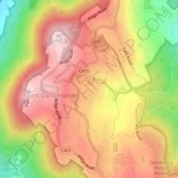
Name: Topografische Karte Dandenong Ranges, Höhe, Relief.

Ort: Dandenong Ranges, Melbourne, Shire of Yarra Ranges, Victoria, 3767, Australia (-37.83532 145.35890 -37.83522 145.35900)

Durchschnittliche Höhe: 456 m

Minimale Höhe: 213 m

Maximale Höhe: 621 m

Andere topografische Karten

Klicken Sie auf eine Karte, um ihre Topografie, ihre Höhe und ihr Relief anzuzeigen.

Manor Lake

Australia > Victoria > Melbourne

Durchschnittliche Höhe: 45 m

Blairgowrie

Australia > Victoria > Melbourne

Durchschnittliche Höhe: 7 m

Vermont South

Australia > Victoria > Melbourne

In 1966 the Metropolitan & Melbourne Board of Works (MMBW) put forth a plan to construct numerous "package" sewage treatment plants in the valleys of Dandenong Creek and its tributaries. The project aimed to provide adequate sewerage to the catchment before the Dandenong Valley Trunk sewer could supersede the…

Durchschnittliche Höhe: 100 m

The Basin

Australia > Victoria > Melbourne

Durchschnittliche Höhe: 230 m

Thomastown

Australia > Victoria > Melbourne

Durchschnittliche Höhe: 106 m

Footscray

Australia > Victoria > Melbourne

Durchschnittliche Höhe: 19 m

Melbourne Water Retarding Basin

Australia > Victoria > Melbourne

Durchschnittliche Höhe: 22 m

Mount Evelyn

Australia > Victoria > Melbourne

Durchschnittliche Höhe: 189 m

Northcote

Australia > Victoria > Melbourne

Durchschnittliche Höhe: 44 m

Chelsea

Australia > Victoria > Melbourne

Durchschnittliche Höhe: 5 m

Brookfield

Australia > Victoria > Melbourne

Durchschnittliche Höhe: 120 m

Warburton

Australia > Victoria > Melbourne

Durchschnittliche Höhe: 525 m

Doncaster

Australia > Victoria > Melbourne

Durchschnittliche Höhe: 77 m

Werribee

Australia > Victoria > Melbourne

Durchschnittliche Höhe: 22 m

Pakenham

Australia > Victoria > Melbourne

Durchschnittliche Höhe: 56 m

Dandenong

Australia > Victoria > Melbourne

Durchschnittliche Höhe: 33 m

Arthurs Seat

Australia > Victoria > Melbourne

Durchschnittliche Höhe: 186 m

Wollert

Australia > Victoria > Melbourne

Durchschnittliche Höhe: 191 m

Mornington District

Australia > Victoria > Melbourne

Durchschnittliche Höhe: 50 m

Surrey Hills

Australia > Victoria > Melbourne

Durchschnittliche Höhe: 96 m

Williamstown

Australia > Victoria > Melbourne

Durchschnittliche Höhe: 4 m

Canterbury

Australia > Victoria > Melbourne

Durchschnittliche Höhe: 78 m

Chirnside Park

Australia > Victoria > Melbourne

Durchschnittliche Höhe: 102 m

Maribyrnong River

Australia > Victoria > Melbourne

Durchschnittliche Höhe: 60 m

Tarneit District

Australia > Victoria > Melbourne

Durchschnittliche Höhe: 45 m

Albert Park District

Australia > Victoria > Melbourne

Durchschnittliche Höhe: 10 m

Glen Iris

Australia > Victoria > Melbourne

Durchschnittliche Höhe: 46 m

Richmond

Australia > Victoria > Melbourne

Durchschnittliche Höhe: 19 m

Science Garden

Australia > Victoria > Melbourne

Durchschnittliche Höhe: 174 m

Iramoo Wildlife Park

Australia > Victoria > Melbourne > Cairnlea

Durchschnittliche Höhe: 63 m