
Topografische Karte Continental Divide
Interaktive Karte
Klicken Sie auf die Karte, um die Höhe anzuzeigen.
Über diese Karte
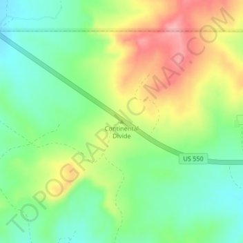
Name: Topografische Karte Continental Divide, Höhe, Relief.
Ort: Continental Divide, Sandoval County, New Mexico, USA (36.07606 -107.13582 36.07616 -107.13572)
Durchschnittliche Höhe: 2.241 m
Minimale Höhe: 2.194 m
Maximale Höhe: 2.306 m
Andere topografische Karten
Klicken Sie auf eine Karte, um ihre Topografie, ihre Höhe und ihr Relief anzuzeigen.
White Sands National Monument
White Sands National Monument, Otero County, New Mexico, USA
Durchschnittliche Höhe: 1.214 m
Valles Caldera
Valles Caldera, 02, Sandoval County, New Mexico, USA
Durchschnittliche Höhe: 2.899 m
Sandia Mountains Historical Marker
USA > New Mexico > Tierra Monte Subdivision
Sandia Mountains Historical Marker, Tierra Monte Subdivision, Bernalillo County, New Mexico, USA
Durchschnittliche Höhe: 2.938 m
Santa Fe National Forest
Santa Fe National Forest, Pueblo Canyon Trail, Los Alamos, Los Alamos County, New Mexico, 87544, USA
Durchschnittliche Höhe: 2.183 m
Capulin Volcano National Monument
USA > New Mexico > Capulin
Capulin Volcano National Monument, Crater Rim Trail, Capulin, Union County, New Mexico, 88414, USA
Durchschnittliche Höhe: 2.195 m
Cross Canyon
Cross Canyon, Sierra County, New Mexico, USA
Durchschnittliche Höhe: 1.777 m
Abiquiu Lake
Abiquiu Lake, Dr 1727 A, Rio Arriba County, New Mexico, USA
Durchschnittliche Höhe: 1.967 m
Chaco Culture National Historical Park
Chaco Culture National Historical Park, South Mesa Trail, San Juan County, New Mexico, USA
Durchschnittliche Höhe: 1.919 m
Mount Phillips
Mount Phillips, Colfax County, New Mexico, USA
Durchschnittliche Höhe: 3.310 m
Acoma Pueblo
USA > New Mexico > Acoma Pueblo
Acoma Pueblo, Cibola County, New Mexico, USA
Durchschnittliche Höhe: 1.929 m
Arroyo
USA > New Mexico > Albuquerque
Arroyo, Albuquerque, Bernalillo County, New Mexico, 87114, USA
Durchschnittliche Höhe: 1.579 m
La Loma
USA > New Mexico > La Loma
La Loma, Santa Fe County, New Mexico, 87504, USA
Durchschnittliche Höhe: 2.163 m
Arroyo
Arroyo, Bernalillo County, New Mexico, 87125, USA
Durchschnittliche Höhe: 1.667 m
Little Walnut Village
USA > New Mexico > Little Walnut Village
Little Walnut Village, Grant County, New Mexico, 88062, USA
Durchschnittliche Höhe: 1.978 m
Cerro Prieto
Cerro Prieto, Catron County, New Mexico, USA
Durchschnittliche Höhe: 2.073 m
Plate Mesa
Plate Mesa, Bernalillo County, New Mexico, USA
Durchschnittliche Höhe: 1.845 m
Ojito Wilderness Study Area
Ojito Wilderness Study Area, Sandoval County, New Mexico, USA
Durchschnittliche Höhe: 1.780 m
El Vado
USA > New Mexico > El Vado
El Vado, Rio Arriba County, New Mexico, USA
Durchschnittliche Höhe: 2.142 m
Rock Canyon
USA > New Mexico > Rock Canyon
Rock Canyon, Sierra County, New Mexico, 86935, USA
Durchschnittliche Höhe: 1.367 m
Jemez Mountains Historical Marker
Jemez Mountains Historical Marker, Jemez Pueblo, Sandoval County, New Mexico, 87024, USA
Durchschnittliche Höhe: 1.714 m
Indian Peaks
Indian Peaks, Catron County, New Mexico, USA
Durchschnittliche Höhe: 2.365 m
Ute Park
USA > New Mexico > Ute Park
Ute Park, Colfax County, New Mexico, 87719, USA
Durchschnittliche Höhe: 2.387 m
Cebolla Wilderness Area
Cebolla Wilderness Area, Armijo Canyon Road, Cibola County, New Mexico, USA
Durchschnittliche Höhe: 2.291 m
Cerro del Grant
Cerro del Grant, Rio Arriba County, New Mexico, USA
Durchschnittliche Höhe: 3.042 m
South Sandia Peak
South Sandia Peak, Bernalillo County, New Mexico, USA
Durchschnittliche Höhe: 2.677 m
Rio Grande Nature Center State Park
USA > New Mexico > Albuquerque
Rio Grande Nature Center State Park, Los Candelarias, Albuquerque, Bernalillo County, New Mexico, USA
Durchschnittliche Höhe: 1.524 m
Conchas Lake
USA > New Mexico > Conchas
Conchas Lake, Central Campground path, Conchas, San Miguel County, New Mexico, 88416, USA
Durchschnittliche Höhe: 1.285 m
Merrill Place
USA > New Mexico > Merrill Place
Merrill Place, McKinley County, New Mexico, USA
Durchschnittliche Höhe: 2.432 m
Newcomb
USA > New Mexico > Newcomb
Newcomb, San Juan County, New Mexico, USA
Durchschnittliche Höhe: 1.699 m
Truchas Peak
Truchas Peak, Rio Arriba County, New Mexico, USA
Durchschnittliche Höhe: 3.639 m
Bisti/De-Na-Zin Wilderness Area
Bisti/De-Na-Zin Wilderness Area, San Juan County, New Mexico, USA
Durchschnittliche Höhe: 1.885 m
Brantley Lake
USA > New Mexico > Seven Rivers
Brantley Lake, County Road 31A, Seven Rivers, Eddy County, New Mexico, USA
Durchschnittliche Höhe: 1.007 m
Beaverhead Ranger Station
USA > New Mexico > Beaverhead Ranger Station
Beaverhead Ranger Station, Catron County, New Mexico, USA
Durchschnittliche Höhe: 2.117 m
Bonito Lake
USA > New Mexico > Bonito
Bonito Lake, FS 107, Bonito, Lincoln County, New Mexico, USA
Durchschnittliche Höhe: 2.366 m
Whitewater Baldy
Whitewater Baldy, Catron County, New Mexico, USA
Durchschnittliche Höhe: 3.013 m
Leasburg
USA > New Mexico > Leasburg
Leasburg, Doña Ana County, New Mexico, 88006, USA
Durchschnittliche Höhe: 1.224 m
Tijeras Canyon Arroyo
USA > New Mexico > Albuquerque
Tijeras Canyon Arroyo, Albuquerque, Bernalillo County, New Mexico, 87123-3909, USA
Durchschnittliche Höhe: 1.746 m
Rucker Canyon
Rucker Canyon, Doña Ana County, New Mexico, USA
Durchschnittliche Höhe: 1.969 m
San Pedro
USA > New Mexico > San Pedro
San Pedro, Santa Fe County, New Mexico, USA
Durchschnittliche Höhe: 2.165 m
Sandia Crest
Sandia Crest, Bernalillo County, New Mexico, USA
Durchschnittliche Höhe: 2.925 m
Bear Canyon Arroyo Open Space
USA > New Mexico > Albuquerque
Bear Canyon Arroyo Open Space, Casa Grande/South Glenwood Hills, Eldorado Heights, Albuquerque, Bernalillo County, New Mexico, USA
Durchschnittliche Höhe: 1.892 m
Quartz Mountain
Quartz Mountain, Doña Ana County, New Mexico, USA
Durchschnittliche Höhe: 1.774 m
Franklin Mountains Historical Marker
Franklin Mountains Historical Marker, Doña Ana County, New Mexico, 88084, USA
Durchschnittliche Höhe: 1.177 m