
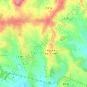
Topografische Karte Saint-Jean-de-la-Forêt
Interaktive Karte
Klicken Sie auf die Karte, um die Höhe anzuzeigen.
Über diese Karte
Name: Topografische Karte Saint-Jean-de-la-Forêt, Höhe, Relief.
Durchschnittliche Höhe: 196 m
Minimale Höhe: 144 m
Maximale Höhe: 270 m
Andere topografische Karten
Klicken Sie auf eine Karte, um ihre Topografie, ihre Höhe und ihr Relief anzuzeigen.
Préaux-du-Perche
France > Normandie > Orne > Perche en Nocé
Préaux-du-Perche, Perche en Nocé, Mortagne-au-Perche, Orne, Normandie, France métropolitaine, 61340, France
Durchschnittliche Höhe: 147 m
Le Brûlé
France > Normandie > Orne > Perche en Nocé
Le Brûlé, Colonard-Corubert, Perche en Nocé, Mortagne-au-Perche, Orne, Normandie, France métropolitaine, 61340, France
Durchschnittliche Höhe: 187 m
Le Rosier
France > Normandie > Orne > Perche en Nocé
Le Rosier, Préaux-du-Perche, Perche en Nocé, Mortagne-au-Perche, Orne, Normandie, France métropolitaine, 61340, France
Durchschnittliche Höhe: 158 m
Dancé
France > Normandie > Orne > Perche en Nocé
Dancé, Perche en Nocé, Mortagne-au-Perche, Orne, Normandie, France métropolitaine, 61340, France
Durchschnittliche Höhe: 147 m
Saint-Aubin-des-Grois
France > Normandie > Orne > Perche en Nocé
Saint-Aubin-des-Grois, Perche en Nocé, Mortagne-au-Perche, Orne, Normandie, France métropolitaine, 61340, France
Durchschnittliche Höhe: 163 m