
Topografische Karte Blue Rock Dam
Interaktive Karte
Klicken Sie auf die Karte, um die Höhe anzuzeigen.
Über diese Karte
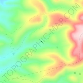
Name: Topografische Karte Blue Rock Dam, Höhe, Relief.
Ort: Blue Rock Dam, Yavapai County, Arizona, United States (34.36576 -111.87571 34.36613 -111.87516)
Durchschnittliche Höhe: 1.563 m
Minimale Höhe: 1.434 m
Maximale Höhe: 1.726 m
Andere topografische Karten
Klicken Sie auf eine Karte, um ihre Topografie, ihre Höhe und ihr Relief anzuzeigen.
Seligman
United States > Arizona > Yavapai County > Seligman
Seligman, Yavapai County, Arizona, 86337, United States
Durchschnittliche Höhe: 1.617 m
Prescott
United States > Arizona > Yavapai County
Prescott, Yavapai County, Arizona, United States
Durchschnittliche Höhe: 1.674 m
Camp Verde
United States > Arizona > Yavapai County
Camp Verde, Yavapai County, Arizona, 86322, United States
Durchschnittliche Höhe: 1.095 m
Lynx Lake
United States > Arizona > Yavapai County
Lynx Lake, Yavapai County, Arizona, United States
Durchschnittliche Höhe: 1.726 m
Walker
United States > Arizona > Yavapai County
Walker, Yavapai County, Arizona, United States
Durchschnittliche Höhe: 2.039 m
Spring Valley
United States > Arizona > Yavapai County
Spring Valley, Yavapai County, Arizona, United States
Durchschnittliche Höhe: 1.200 m
Sedona
United States > Arizona > Yavapai County
Sedona, Yavapai County, Arizona, 86336, United States
Durchschnittliche Höhe: 1.342 m
Sedona City Limit
United States > Arizona > Yavapai County
Sedona City Limit, Yavapai County, Arizona, 86336, United States
Durchschnittliche Höhe: 1.348 m
Big Park
United States > Arizona > Yavapai County
Big Park, Yavapai County, Arizona, 86351, United States
Durchschnittliche Höhe: 1.333 m
Skull Valley
United States > Arizona > Yavapai County
Skull Valley, Yavapai County, Arizona, 86338, United States
Durchschnittliche Höhe: 1.342 m
Tapco
United States > Arizona > Yavapai County
Tapco, Yavapai County, Arizona, 86324, United States
Durchschnittliche Höhe: 1.083 m
Yarnell
United States > Arizona > Yavapai County
Yarnell, Yavapai County, Arizona, 85362, United States
Durchschnittliche Höhe: 1.472 m
Peeples Valley
United States > Arizona > Yavapai County
Peeples Valley, Yavapai County, Arizona, 86332, United States
Durchschnittliche Höhe: 1.472 m
Verde Village
United States > Arizona > Yavapai County
Verde Village, Yavapai County, Arizona, United States
Durchschnittliche Höhe: 1.040 m
Lake Montezuma
United States > Arizona > Yavapai County > Rimrock
Lake Montezuma, Rimrock, Yavapai County, Arizona, United States
Durchschnittliche Höhe: 1.075 m
Rimrock
United States > Arizona > Yavapai County
Rimrock, Yavapai County, Arizona, 86342, United States
Durchschnittliche Höhe: 1.092 m
Black Canyon City
United States > Arizona > Yavapai County
Black Canyon City, Yavapai County, Arizona, 85324, United States
Durchschnittliche Höhe: 700 m
Perkinsville
United States > Arizona > Yavapai County
Perkinsville, Yavapai County, Arizona, United States
Durchschnittliche Höhe: 1.256 m
Chimney Rock
United States > Arizona > Yavapai County
Chimney Rock, Yavapai County, Arizona, 86336, United States
Durchschnittliche Höhe: 1.441 m
Kirkland
United States > Arizona > Yavapai County
Kirkland, Yavapai County, Arizona, United States
Durchschnittliche Höhe: 1.228 m
Williamson Valley Wash
United States > Arizona > Yavapai County
Williamson Valley Wash, Yavapai County, Arizona, United States
Durchschnittliche Höhe: 1.337 m
Dewey-Humboldt
United States > Arizona > Yavapai County
Dewey-Humboldt, Yavapai County, Arizona, 86329, United States
Durchschnittliche Höhe: 1.464 m
Clarkdale
United States > Arizona > Yavapai County
Clarkdale, Yavapai County, Arizona, 86324, United States
Durchschnittliche Höhe: 1.211 m
Paradise Acres
United States > Arizona > Yavapai County > Camp Verde
Paradise Acres, Camp Verde, Yavapai County, Arizona, United States
Durchschnittliche Höhe: 948 m
Paulden
United States > Arizona > Yavapai County
Paulden, Yavapai County, Arizona, United States
Durchschnittliche Höhe: 1.408 m
Mount Union Family Picnic Ground
United States > Arizona > Yavapai County
Mount Union Family Picnic Ground, Yavapai County, Arizona, United States
Durchschnittliche Höhe: 2.232 m
Arcosanti
United States > Arizona > Yavapai County
Arcosanti, Yavapai County, Arizona, United States
Durchschnittliche Höhe: 1.130 m
Lake Pleasant
United States > Arizona > Yavapai County > Peoria
Lake Pleasant, Peoria, Yavapai County, Arizona, United States
Durchschnittliche Höhe: 565 m
Chino Valley
United States > Arizona > Yavapai County
Chino Valley, Yavapai County, Arizona, 86323, United States
Durchschnittliche Höhe: 1.454 m
Mesa Verde Estates
United States > Arizona > Yavapai County > Camp Verde
Mesa Verde Estates, Camp Verde, Yavapai County, Arizona, 86322, United States
Durchschnittliche Höhe: 969 m
Jacks Canyon
United States > Arizona > Yavapai County
Jacks Canyon, Yavapai County, Arizona, United States
Durchschnittliche Höhe: 1.507 m
Ocotillo
United States > Arizona > Yavapai County
Ocotillo, Yavapai County, Arizona, United States
Durchschnittliche Höhe: 1.302 m
Prescott Valley
United States > Arizona > Yavapai County
Prescott Valley, Yavapai County, Arizona, United States
Durchschnittliche Höhe: 1.550 m
Cedar Bench Wilderness
United States > Arizona > Yavapai County
Cedar Bench Wilderness, Yavapai County, Arizona, United States
Durchschnittliche Höhe: 1.349 m
Clear Creek
United States > Arizona > Yavapai County > Camp Verde
Clear Creek, Camp Verde, Yavapai County, Arizona, United States
Durchschnittliche Höhe: 954 m
Mayer
United States > Arizona > Yavapai County
Mayer, Yavapai County, Arizona, United States
Durchschnittliche Höhe: 1.427 m
Jerome
United States > Arizona > Yavapai County
Jerome, Yavapai County, Arizona, 86331, United States
Durchschnittliche Höhe: 1.574 m
Miller Valley
United States > Arizona > Yavapai County > Prescott
Miller Valley, Prescott, Yavapai County, Arizona, 86305, United States
Durchschnittliche Höhe: 1.663 m
Granite Mountain Wilderness
United States > Arizona > Yavapai County
Granite Mountain Wilderness, Yavapai County, Arizona, United States
Durchschnittliche Höhe: 1.718 m
Seligman
United States > Arizona > Yavapai County
Seligman, Yavapai County, Arizona, 86337, United States
Durchschnittliche Höhe: 1.617 m
Cordes Lakes
United States > Arizona > Yavapai County
Cordes Lakes, Yavapai County, Arizona, United States
Durchschnittliche Höhe: 1.141 m
Ruin Point Tank
United States > Arizona > Yavapai County
Ruin Point Tank, Yavapai County, Arizona, United States
Durchschnittliche Höhe: 939 m
Ash Fork
United States > Arizona > Yavapai County
Ash Fork, Yavapai County, Arizona, 86320, United States
Durchschnittliche Höhe: 1.561 m
Granite Mountain
United States > Arizona > Yavapai County
Granite Mountain, Yavapai County, Arizona, United States
Durchschnittliche Höhe: 1.915 m
Crown King
United States > Arizona > Yavapai County
Crown King, Yavapai County, Arizona, 86343, United States
Durchschnittliche Höhe: 1.902 m
Willow Spring
United States > Arizona > Yavapai County
Willow Spring, Yavapai County, Arizona, United States
Durchschnittliche Höhe: 1.447 m
Yava
United States > Arizona > Yavapai County
Yava, Yavapai County, Arizona, United States
Durchschnittliche Höhe: 1.095 m
Agua Fria National Monument
United States > Arizona > Yavapai County
Agua Fria National Monument, Yavapai County, Arizona, United States
Durchschnittliche Höhe: 1.161 m
House Mountain
United States > Arizona > Yavapai County
House Mountain, Yavapai County, Arizona, United States
Durchschnittliche Höhe: 1.417 m
Cottonwood
United States > Arizona > Yavapai County
Cottonwood, Yavapai County, Arizona, 86236, United States
Durchschnittliche Höhe: 1.118 m