
Spenden
Topografische Karte Kirkland Lake
Klicken Sie auf die Karte, um die Höhe anzuzeigen.
Spenden
Kirkland Lake
Kirkland Lake is located in the resource-rich Precambrian Shield, an ancient geological core of the North American continent. Nearby is the Arctic Watershed, a drainage divide at an elevation of 318 m (1,043 ft). Rivers south of that elevation flow into a drainage basin which includes Lake Ontario and the Saint Lawrence River, while rivers north of the watershed flow into Hudson Bay.
Spenden
Über diese Karte
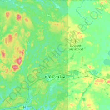
Name: Topografische Karte Kirkland Lake, Höhe, Relief.
Durchschnittliche Höhe: 332 m
Minimale Höhe: 294 m
Maximale Höhe: 443 m
Spenden
Andere topografische Karten
Klicken Sie auf eine Karte, um ihre Topografie, ihre Höhe und ihr Relief anzuzeigen.
Sesekinika
Canada > Ontario > Timiskaming District > Unorganized West Timiskaming
Durchschnittliche Höhe: 320 m
Echo Lake
Canada > Ontario > Timiskaming District > Unorganized West Timiskaming
Durchschnittliche Höhe: 339 m