
Topografische Karte Wolf Mountain
Interaktive Karte
Klicken Sie auf die Karte, um die Höhe anzuzeigen.
Über diese Karte
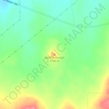
Name: Topografische Karte Wolf Mountain, Höhe, Relief.
Ort: Wolf Mountain, Potter County, Texas, United States (35.25834 -102.01774 35.25844 -102.01764)
Durchschnittliche Höhe: 1.091 m
Minimale Höhe: 1.060 m
Maximale Höhe: 1.141 m
Andere topografische Karten
Klicken Sie auf eine Karte, um ihre Topografie, ihre Höhe und ihr Relief anzuzeigen.
Amarillo
United States > Texas > Potter County > Amarillo
Amarillo, Potter County, Texas, 79105, United States
Durchschnittliche Höhe: 1.090 m
Amarillo
United States > Texas > Potter County
Amarillo, Potter County, Texas, United States
Durchschnittliche Höhe: 1.097 m