
Topografische Karte Andalo
Interaktive Karte
Klicken Sie auf die Karte, um die Höhe anzuzeigen.
Über diese Karte
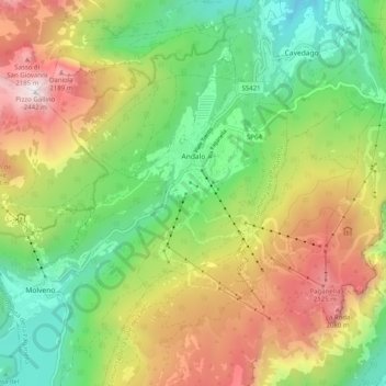
Name: Topografische Karte Andalo, Höhe, Relief.
Durchschnittliche Höhe: 1.369 m
Minimale Höhe: 655 m
Maximale Höhe: 2.412 m
The town lies on the Paganella plateau, between the mountains Piz Galin, elevation 2,442 metres (8,012 ft), and Paganella, 2,125 metres (6,972 ft), and its territory is part of the Adamello-Brenta natural park.