
Vielen Dank für die Unterstützung dieser Website ❤️
Spenden
Spenden
Topografische Karte Entriken
Klicken Sie auf die Karte, um die Höhe anzuzeigen.
Vielen Dank für die Unterstützung dieser Website ❤️
Spenden
Spenden
Über diese Karte
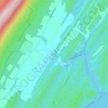
Name: Topografische Karte Entriken, Höhe, Relief.
Durchschnittliche Höhe: 324 m
Minimale Höhe: 239 m
Maximale Höhe: 680 m
Vielen Dank für die Unterstützung dieser Website ❤️
Spenden
Spenden
Andere topografische Karten
Klicken Sie auf eine Karte, um ihre Topografie, ihre Höhe und ihr Relief anzuzeigen.
Raystown Lake
United States > Pennsylvania > Huntingdon County > Lincoln Township
The proposal for the new dam incorporated the ideas of bringing tourism into the area, promoting recreation, and flood control. The actual purpose stated, "The project will provide flood control, recreation, water quality and fish and wildlife enhancement" (U.S. Army Corps of Engineers, 1974). Although tourism…
Durchschnittliche Höhe: 380 m