
Spenden
Topografische Karte Combe
Klicken Sie auf die Karte, um die Höhe anzuzeigen.
Spenden
Über diese Karte
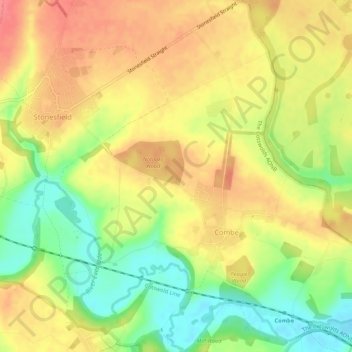
Name: Topografische Karte Combe, Höhe, Relief.
Ort: Combe, West Oxfordshire, Oxfordshire, England, United Kingdom (51.82895 -1.42884 51.86225 -1.37890)
Durchschnittliche Höhe: 106 m
Minimale Höhe: 68 m
Maximale Höhe: 135 m
Spenden
Andere topografische Karten
Klicken Sie auf eine Karte, um ihre Topografie, ihre Höhe und ihr Relief anzuzeigen.
Long Hanborough
United Kingdom > England > Oxfordshire > West Oxfordshire
Durchschnittliche Höhe: 95 m
Broughton Poggs
United Kingdom > England > Oxfordshire > West Oxfordshire
Durchschnittliche Höhe: 90 m
Spenden
Ledwell
United Kingdom > England > Oxfordshire > West Oxfordshire > Sandford St. Martin
Durchschnittliche Höhe: 142 m
Eynsham Mill
United Kingdom > England > Oxfordshire > West Oxfordshire > Eynsham
Durchschnittliche Höhe: 71 m
Shipton-under-Wychwood
United Kingdom > England > Oxfordshire > West Oxfordshire
Durchschnittliche Höhe: 131 m
Spenden
Great Park
United Kingdom > England > Oxfordshire > West Oxfordshire > Long Hanborough
Durchschnittliche Höhe: 94 m
Spenden
Upper Milton
United Kingdom > England > Oxfordshire > West Oxfordshire > Milton-under-Wychwood
Durchschnittliche Höhe: 153 m
Spenden
Church Hanborough
United Kingdom > England > Oxfordshire > West Oxfordshire
Durchschnittliche Höhe: 85 m
Great Rollright
United Kingdom > England > Oxfordshire > West Oxfordshire
Durchschnittliche Höhe: 193 m
Long Hanborough
United Kingdom > England > Oxfordshire > West Oxfordshire
Durchschnittliche Höhe: 95 m
Spenden