
Topografische Karte Dolores County
Interaktive Karte
Klicken Sie auf die Karte, um die Höhe anzuzeigen.
Über diese Karte
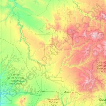
Name: Topografische Karte Dolores County, Höhe, Relief.
Ort: Dolores County, Colorado, United States of America (37.48072 -109.04348 37.89640 -107.86155)
Durchschnittliche Höhe: 2.385 m
Minimale Höhe: 1.473 m
Maximale Höhe: 4.265 m
Dolores County, like other counties in Colorado along its border with Utah, is split into two geographically distinct regions, and in fact, under normal travel conditions, it is necessary to leave the county to travel between the two regions. The western portion of the county (east of the Dolores River Canyon and along the Utah border) is the northern portion of the Great Sage Plain, relatively low (6500–7500 feet in elevation) and flat (but cut by large canyons, including that of the Dolores River itself), and consists of irrigated and dryland farming areas; it is especially well known for the cultivation of various varieties of beans, including pinto beans and many variety of old Anasazi beans. The central portion of the county has higher open grasslands with forested hills, ravines, and canyons, used for livestock raising. The eastern portion of the county is located in the highest peaks of the San Juan Mountains, around the old mining and modern tourist town of Rico, and except for cattle grazing in the San Juan National Forest, has virtually no agriculture, in part because its elevations range from 9,000 to 14,000+. Rico is developing in many ways as a bedroom community for the much wealthier town of Telluride in San Miguel County to the north.
Andere topografische Karten
Klicken Sie auf eine Karte, um ihre Topografie, ihre Höhe und ihr Relief anzuzeigen.
Crested Butte
United States of America > Colorado > Crested Butte
Crested Butte, Gunnison County, Colorado, 81224, United States of America
Durchschnittliche Höhe: 2.798 m
Dream Lake
United States of America > Colorado
Dream Lake, Flat Top Mountain Trail, Larimer County, Colorado, United States of America
Durchschnittliche Höhe: 3.150 m
Wild Horse
United States of America > Colorado > Wild Horse
Wild Horse, Pueblo County, Colorado, United States of America
Durchschnittliche Höhe: 1.496 m
Centennial
United States of America > Colorado > Centennial
Centennial, Arapahoe County, Colorado, United States of America
Durchschnittliche Höhe: 1.722 m
Rio Grande County
United States of America > Colorado
Rio Grande County, Colorado, United States of America
Durchschnittliche Höhe: 2.771 m
Rio Blanco County
United States of America > Colorado
Rio Blanco County, Colorado, United States of America
Durchschnittliche Höhe: 2.161 m
Idaho Springs
United States of America > Colorado > Idaho Springs
Idaho Springs, Clear Creek County, Colorado, United States of America
Durchschnittliche Höhe: 2.684 m
White Hills
United States of America > Colorado
White Hills, Custer County, Colorado, 81252, United States of America
Durchschnittliche Höhe: 2.447 m
Mount Arthur
United States of America > Colorado
Mount Arthur, El Paso County, Colorado, United States of America
Durchschnittliche Höhe: 3.002 m
Telluride
United States of America > Colorado > Telluride
Telluride, San Miguel County, Colorado, United States of America
Durchschnittliche Höhe: 3.125 m
Alamosa County
United States of America > Colorado
Alamosa County, Colorado, United States of America
Durchschnittliche Höhe: 2.359 m
Quandary Peak
United States of America > Colorado
Quandary Peak, Summit County, Colorado, United States of America
Durchschnittliche Höhe: 3.833 m
Golden
United States of America > Colorado > Golden
Golden, Jefferson County, Colorado, United States of America
Durchschnittliche Höhe: 1.940 m