
Topografische Karte Getafe
Interaktive Karte
Klicken Sie auf die Karte, um die Höhe anzuzeigen.
Über diese Karte
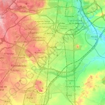
Name: Topografische Karte Getafe, Höhe, Relief.
Durchschnittliche Höhe: 631 m
Minimale Höhe: 549 m
Maximale Höhe: 726 m
Getafe is located in the southern zone of the autonomous community of Madrid, Spain, in southwestern Europe. It is physically located in the centre of the Iberian Peninsula, north of the Southern Submeseta (part of the Meseta Central), in the Manzanares River basin. Its elevation is 610 – 640 meters above sea level (2000–2100 feet). Its coordinates are 40° 18' N 3° 43' W. The municipal district is 78.74 km2, with a perimeter of 46.5 km. The easternmost part of the municipal district is located within the Parque Regional del Sureste, a protected forest region.
Andere topografische Karten
Klicken Sie auf eine Karte, um ihre Topografie, ihre Höhe und ihr Relief anzuzeigen.
Pinto
Spain > Community of Madrid > Área metropolitana de Madrid y Corredor del Henares
Pinto, Área metropolitana de Madrid y Corredor del Henares, Community of Madrid, 28320, Spain
Durchschnittliche Höhe: 618 m
Leganés
Spain > Community of Madrid > Área metropolitana de Madrid y Corredor del Henares
Leganés, Área metropolitana de Madrid y Corredor del Henares, Community of Madrid, Spain
Durchschnittliche Höhe: 656 m
Villaverde
Spain > Community of Madrid > Área metropolitana de Madrid y Corredor del Henares > Madrid
Villaverde, Madrid, Área metropolitana de Madrid y Corredor del Henares, Community of Madrid, 28001, Spain
Durchschnittliche Höhe: 599 m
Alcorcón
Spain > Community of Madrid > Área metropolitana de Madrid y Corredor del Henares > Alcorcón
Alcorcón, Área metropolitana de Madrid y Corredor del Henares, Community of Madrid, 28921, Spain
Durchschnittliche Höhe: 646 m
Pozuelo de Alarcón
Spain > Community of Madrid > Área metropolitana de Madrid y Corredor del Henares
Pozuelo de Alarcón, Área metropolitana de Madrid y Corredor del Henares, Community of Madrid, Spain
Durchschnittliche Höhe: 688 m
Boadilla del Monte
Spain > Community of Madrid > Área metropolitana de Madrid y Corredor del Henares
Boadilla del Monte, Área metropolitana de Madrid y Corredor del Henares, Community of Madrid, Spain
Durchschnittliche Höhe: 695 m
Alcorcón
Spain > Community of Madrid > Área metropolitana de Madrid y Corredor del Henares
Alcorcón, Área metropolitana de Madrid y Corredor del Henares, Community of Madrid, Spain
Durchschnittliche Höhe: 692 m