
Topografische Karte Abilene
Interaktive Karte
Klicken Sie auf die Karte, um die Höhe anzuzeigen.
Über diese Karte
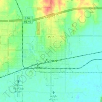
Name: Topografische Karte Abilene, Höhe, Relief.
Ort: Abilene, Dickinson County, Kansas, United States (38.89601 -97.26351 38.94806 -97.19962)
Durchschnittliche Höhe: 357 m
Minimale Höhe: 343 m
Maximale Höhe: 390 m
Abilene is at 38°55′11″N 97°13′2″W / 38.91972°N 97.21722°W / 38.91972; -97.21722 (38.919721, −97.217329) at an elevation of 1,155 feet (352 m). The city is on the north side of the Smoky Hill River in the Flint Hills region of the Great Plains. Mud Creek, a tributary of the Smoky Hill, flows south through the city. Located in North Central Kansas at the intersection of Interstate 70 and K-15, Abilene is approximately 27 mi (43 km) east of Salina, Kansas, 94 mi (151 km) north of Wichita, and 139 mi (224 km) west of Kansas City.
Andere topografische Karten
Klicken Sie auf eine Karte, um ihre Topografie, ihre Höhe und ihr Relief anzuzeigen.
Enterprise
United States > Kansas > Dickinson County
Enterprise, Dickinson County, Kansas, United States
Durchschnittliche Höhe: 354 m
Chapman
United States > Kansas > Dickinson County
Chapman, Dickinson County, Kansas, 67431, United States
Durchschnittliche Höhe: 349 m
Herington
United States > Kansas > Dickinson County
Herington, Dickinson County, Kansas, United States
Durchschnittliche Höhe: 415 m
Talmage
United States > Kansas > Dickinson County
Talmage, Dickinson County, Kansas, 67482, United States
Durchschnittliche Höhe: 380 m
Solomon
United States > Kansas > Dickinson County
Solomon, Dickinson County, Kansas, United States
Durchschnittliche Höhe: 364 m