
Topografische Karte Rim Rock Lake
Interaktive Karte
Klicken Sie auf die Karte, um die Höhe anzuzeigen.
Über diese Karte
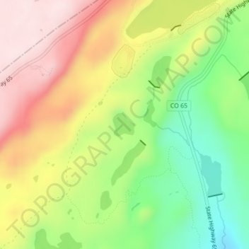
Name: Topografische Karte Rim Rock Lake, Höhe, Relief.
Ort: Rim Rock Lake, Delta County, Colorado, United States (39.02161 -108.01074 39.02413 -108.00772)
Durchschnittliche Höhe: 3.113 m
Minimale Höhe: 2.930 m
Maximale Höhe: 3.302 m
Andere topografische Karten
Klicken Sie auf eine Karte, um ihre Topografie, ihre Höhe und ihr Relief anzuzeigen.
Austin
United States > Colorado > Delta County
Austin, Delta County, Colorado, 81410, United States
Durchschnittliche Höhe: 1.576 m
Delta
United States > Colorado > Delta County
Delta, Delta County, Colorado, 81416, United States
Durchschnittliche Höhe: 1.550 m
Cedaredge
United States > Colorado > Delta County
Cedaredge, Delta County, Colorado, United States
Durchschnittliche Höhe: 1.883 m
Crawford
United States > Colorado > Delta County
Crawford, Delta County, Colorado, United States
Durchschnittliche Höhe: 2.020 m
Hotchkiss
United States > Colorado > Delta County
Hotchkiss, Delta County, Colorado, United States
Durchschnittliche Höhe: 1.655 m
Paonia
United States > Colorado > Delta County
Paonia, Delta County, Colorado, United States
Durchschnittliche Höhe: 1.760 m