
Topografische Karte Cloud Peak
Interaktive Karte
Klicken Sie auf die Karte, um die Höhe anzuzeigen.
Über diese Karte
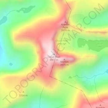
Name: Topografische Karte Cloud Peak, Höhe, Relief.
Ort: Cloud Peak, Big Horn County, Wyoming, United States (44.38214 -107.17400 44.38224 -107.17390)
Durchschnittliche Höhe: 3.598 m
Minimale Höhe: 3.219 m
Maximale Höhe: 4.016 m
It rises to an elevation of 13,171 feet (4,015 m) and provides onlookers with dramatic views and vistas. The mountain can be climbed most easily from the western side, accessed by either the Battle Park or West Tensleep trail-heads and is roughly 24 miles round-trip from both. The peak is located in the 189,000 acre (765 km²) Cloud Peak Wilderness within Bighorn National Forest. The northeast slope of Cloud Peak is a deep cirque which harbors Cloud Peak Glacier, the last active glacier in the Bighorn Mountains.