
Topografische Karte Swartkops River
Interaktive Karte
Klicken Sie auf die Karte, um die Höhe anzuzeigen.
Über diese Karte
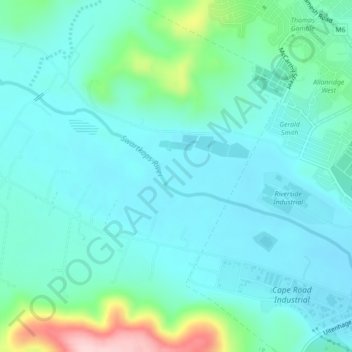
Name: Topografische Karte Swartkops River, Höhe, Relief.
Durchschnittliche Höhe: 83 m
Minimale Höhe: 39 m
Maximale Höhe: 270 m
Andere topografische Karten
Klicken Sie auf eine Karte, um ihre Topografie, ihre Höhe und ihr Relief anzuzeigen.
Nelson Mandela Bay Ward 42
RSA > Eastern Cape > Port Elizabeth
Nelson Mandela Bay Ward 42, Port Elizabeth, Nelson Mandela Bay Metropolitan Municipality, Eastern Cape, RSA
Durchschnittliche Höhe: 124 m
Nelson Mandela Bay Ward 1
RSA > Eastern Cape > Port Elizabeth
Nelson Mandela Bay Ward 1, Port Elizabeth, Nelson Mandela Bay Metropolitan Municipality, Eastern Cape, 6070, RSA
Durchschnittliche Höhe: 76 m
Nelson Mandela Bay Ward 41
RSA > Eastern Cape > Port Elizabeth
Nelson Mandela Bay Ward 41, Port Elizabeth, Nelson Mandela Bay Metropolitan Municipality, Eastern Cape, RSA
Durchschnittliche Höhe: 105 m
Brenton Island
RSA > Eastern Cape > Port Elizabeth
Brenton Island, Port Elizabeth, Eastern Cape, RSA
Durchschnittliche Höhe: 0 m
Jahleel Island
RSA > Eastern Cape > Port Elizabeth
Jahleel Island, Port Elizabeth, Eastern Cape, RSA
Durchschnittliche Höhe: 1 m