
Topografische Karte Boťany
Interaktive Karte
Klicken Sie auf die Karte, um die Höhe anzuzeigen.
Über diese Karte
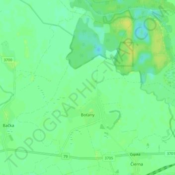
Name: Topografische Karte Boťany, Höhe, Relief.
Durchschnittliche Höhe: 101 m
Minimale Höhe: 94 m
Maximale Höhe: 110 m
Andere topografische Karten
Klicken Sie auf eine Karte, um ihre Topografie, ihre Höhe und ihr Relief anzuzeigen.
Zemplín
Slovakia > Region of Košice > District of Trebišov
Zemplín, District of Trebišov, Region of Košice, Eastern Slovakia, 076 34, Slovakia
Durchschnittliche Höhe: 116 m
Borša
Slovakia > Region of Košice > District of Trebišov
Borša, District of Trebišov, Region of Košice, Eastern Slovakia, 076 32, Slovakia
Durchschnittliche Höhe: 114 m
Kysta
Slovakia > Region of Košice > District of Trebišov
Kysta, District of Trebišov, Region of Košice, Eastern Slovakia, Slovakia
Durchschnittliche Höhe: 177 m
Borša
Slovakia > Region of Košice > District of Trebišov > Borša > Borša
Borša, District of Trebišov, Region of Košice, Eastern Slovakia, 076 32, Slovakia
Durchschnittliche Höhe: 110 m