
Topografische Karte Place Fell
Klicken Sie auf die Karte, um die Höhe anzuzeigen.
Place Fell
Place Fell can be climbed from Patterdale, either via Boredale Hause or more directly by aiming up the face between Bleaberry Knott and The Knight. Ascents can also be made from Sandwick up either of the north eastern ridges, or from Boredale via the Hause. The altitude gain from the shores of Ullswater to the peak of Place Fell is 512 m (1,680 ft), but trails have shallow gradients and no hands-on scrambling is required; scrambling opportunities are few, even off-trail.
Über diese Karte
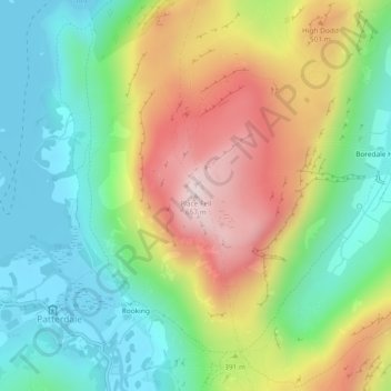
Name: Topografische Karte Place Fell, Höhe, Relief.
Durchschnittliche Höhe: 341 m
Minimale Höhe: 145 m
Maximale Höhe: 653 m
Andere topografische Karten
Klicken Sie auf eine Karte, um ihre Topografie, ihre Höhe und ihr Relief anzuzeigen.
Brown Cove Tarn
United Kingdom > England > Westmorland and Furness > Patterdale
Durchschnittliche Höhe: 699 m
Hard Tarn
United Kingdom > England > Westmorland and Furness > Patterdale
Durchschnittliche Höhe: 630 m
Brothers Water
United Kingdom > England > Westmorland and Furness > Patterdale > Hartsop
Durchschnittliche Höhe: 298 m
Norfolk Isle
United Kingdom > England > Westmorland and Furness > Patterdale
Durchschnittliche Höhe: 260 m