Geolokalisieren
👉 Easily get elevation data in JSON, GeoTIFF and KML formats using Elevation API
Vielen Dank für die Unterstützung dieser Website ❤️
Spenden

Topografische Karte Rockhampton

Klicken Sie auf die Karte, um die Höhe anzuzeigen.

👉 Easily get elevation data in JSON, GeoTIFF and KML formats using Elevation API
Vielen Dank für die Unterstützung dieser Website ❤️
Spenden

Über diese Karte

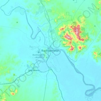
Name: Topografische Karte Rockhampton, Höhe, Relief.

Ort: Rockhampton, Rockhampton Regional, Queensland, 7200, Australia (-23.53821 150.35342 -23.21821 150.67342)

Durchschnittliche Höhe: 48 m

Minimale Höhe: -3 m

Maximale Höhe: 587 m

👉 Easily get elevation data in JSON, GeoTIFF and KML formats using Elevation API
Vielen Dank für die Unterstützung dieser Website ❤️
Spenden

Andere topografische Karten

Klicken Sie auf eine Karte, um ihre Topografie, ihre Höhe und ihr Relief anzuzeigen.

Branyan

Australia > Queensland > Bundaberg Region > Bundaberg

Durchschnittliche Höhe: 27 m

Bundaberg Region

Australia > Queensland

Durchschnittliche Höhe: 70 m

Meadowbrook

Australia > Queensland

Durchschnittliche Höhe: 12 m

City of Brisbane

Australia > Queensland

Brisbane's topography is characterized by a series of hills and ranges that define its landscape. The city is situated on a low-lying floodplain, with the Brisbane River meandering through its heart, creating a winding course with many steep curves from the southwest to its mouth at Moreton Bay in the east.…

Durchschnittliche Höhe: 71 m

Vielen Dank für die Unterstützung dieser Website ❤️
Spenden

Biloela

Australia > Queensland

Durchschnittliche Höhe: 176 m

Fraser Coast Regional

Australia > Queensland

Durchschnittliche Höhe: 37 m

Belmont

Australia > Queensland

Durchschnittliche Höhe: 30 m

Brisbane

Australia > Queensland

Durchschnittliche Höhe: 87 m

Vielen Dank für die Unterstützung dieser Website ❤️
Spenden

Kybong

Australia > Queensland

Durchschnittliche Höhe: 89 m

Lefthand Branch

Australia > Queensland

Durchschnittliche Höhe: 438 m

Scenic Rim Regional

Australia > Queensland

Durchschnittliche Höhe: 261 m

Albany Creek

Australia > Queensland

Durchschnittliche Höhe: 37 m

Vielen Dank für die Unterstützung dieser Website ❤️
Spenden

Mud Island

Australia > Queensland

Durchschnittliche Höhe: 1 m

Lannercost

Australia > Queensland

Durchschnittliche Höhe: 110 m

Hamilton Island

Australia > Queensland

Durchschnittliche Höhe: 21 m

Manly

Australia > Queensland

Durchschnittliche Höhe: 13 m

Vielen Dank für die Unterstützung dieser Website ❤️
Spenden

Logan City

Australia > Queensland

Durchschnittliche Höhe: 61 m

Baffle Creek

Australia > Queensland

Durchschnittliche Höhe: 67 m

Ferny Hills

Australia > Queensland

Durchschnittliche Höhe: 100 m

Sunshine Beach

Australia > Queensland

Durchschnittliche Höhe: 26 m

Vielen Dank für die Unterstützung dieser Website ❤️
Spenden

Maryborough

Australia > Queensland

Durchschnittliche Höhe: 14 m

Mundoolun

Australia > Queensland

Durchschnittliche Höhe: 83 m

North Stradbroke Island

Australia > Queensland > Redland City

Durchschnittliche Höhe: 12 m

Alexandra Hills

Australia > Queensland

Scribbly Gums Conservation Area is located on the eastern edge of Alexandra Hills, bordered by Redland Hospital to the east, and Flinders St and Winchester Rd to the north. The conservation area occupies approximately 152 hectares and contains the Redlands Track Park - a collection of 30+ mountain bike trails…

Durchschnittliche Höhe: 34 m

Vielen Dank für die Unterstützung dieser Website ❤️
Spenden

Sunshine Coast Regional

Australia > Queensland

The Sunshine Coast Regional area in Queensland, Australia, features a diverse topography that ranges from coastal plains to rugged hinterlands. Along the coastline, the terrain is predominantly flat, with average elevations around 20 meters (66 feet) above sea level. Inland, the landscape transitions to…

Durchschnittliche Höhe: 56 m

Cabbage Tree Creek

Australia > Queensland > Brisbane City

Durchschnittliche Höhe: 6 m

Buderim

Australia > Queensland > Sunshine Coast Regional

Durchschnittliche Höhe: 32 m

Evelyn

Australia > Queensland

Durchschnittliche Höhe: 1.033 m

Vielen Dank für die Unterstützung dieser Website ❤️
Spenden

Carina Heights

Australia > Queensland

Durchschnittliche Höhe: 36 m

Elliot River

Australia > Queensland > Bowen

Durchschnittliche Höhe: 72 m

Cedar Creek

Australia > Queensland

Durchschnittliche Höhe: 223 m

Aloomba

Australia > Queensland

Durchschnittliche Höhe: 233 m

Vielen Dank für die Unterstützung dieser Website ❤️
Spenden

Rita Island

Australia > Queensland

Durchschnittliche Höhe: 5 m

Dingo

Australia > Queensland

Durchschnittliche Höhe: 192 m

Ravenswood

Australia > Queensland

Durchschnittliche Höhe: 222 m

Vielen Dank für die Unterstützung dieser Website ❤️
Spenden

Whitsunday Islands National Park

Australia > Queensland

Durchschnittliche Höhe: 27 m

Brisbane River

Australia > Queensland

The RAAF also perform a practice session in the days preceding the event, serving as an opportunity to both practice beforehand and also promote Riverfire. One of the most popular RAAF aircraft to perform at Riverfire was the F-111 which was known for performing a 'dump-and-burn' above the city. The final…

Durchschnittliche Höhe: 235 m

Main Range National Park

Australia > Queensland

Durchschnittliche Höhe: 537 m

Eungella National Park

Australia > Queensland

Durchschnittliche Höhe: 477 m

Vielen Dank für die Unterstützung dieser Website ❤️
Spenden

Mount Rascal

Australia > Queensland

Durchschnittliche Höhe: 622 m

Mount Surprise

Australia > Queensland

Durchschnittliche Höhe: 566 m

Mount Sheridan

Australia > Queensland

Durchschnittliche Höhe: 146 m

Broadbeach Waters

Australia > Queensland > Gold Coast City

Durchschnittliche Höhe: 3 m

Vielen Dank für die Unterstützung dieser Website ❤️
Spenden

Herbert River

Australia > Queensland

With its headwaters forming at an elevation of 1,070 metres (3,510 ft) on the Atherton Tableland, part of the Great Dividing Range west of Herberton and north of Ravenshoe, the Herbert River is formed by the confluence of the Millstream and the Wild River. The Herbert River flows in a generally southeastern…

Durchschnittliche Höhe: 458 m

Sandgate

Australia > Queensland > Brisbane City

Durchschnittliche Höhe: 6 m

Moreton Bay Regional

Australia > Queensland

Durchschnittliche Höhe: 110 m

Southport

Australia > Queensland > Gold Coast

Durchschnittliche Höhe: 10 m

Vielen Dank für die Unterstützung dieser Website ❤️
Spenden

Greenvale

Australia > Queensland

Durchschnittliche Höhe: 547 m

Calamvale

Australia > Queensland > Brisbane City

Durchschnittliche Höhe: 53 m

Wynnum West

Australia > Queensland

Durchschnittliche Höhe: 15 m

Mudgeeraba

Australia > Queensland > Gold Coast

Durchschnittliche Höhe: 50 m

Vielen Dank für die Unterstützung dieser Website ❤️
Spenden

Clear Mountain

Australia > Queensland

Durchschnittliche Höhe: 106 m

Lockyer Valley Regional

Australia > Queensland

Durchschnittliche Höhe: 360 m

Toowong

Australia > Queensland

Durchschnittliche Höhe: 33 m

Topaz

Australia > Queensland

Durchschnittliche Höhe: 639 m

Vielen Dank für die Unterstützung dieser Website ❤️
Spenden

Narangba

Australia > Queensland

Durchschnittliche Höhe: 56 m

Stafford

Australia > Queensland

Durchschnittliche Höhe: 40 m

Widgee

Australia > Queensland

Durchschnittliche Höhe: 278 m

Kallangur

Australia > Queensland

Durchschnittliche Höhe: 28 m

Vielen Dank für die Unterstützung dieser Website ❤️
Spenden

Waterford West

Australia > Queensland

Durchschnittliche Höhe: 14 m

Molendinar

Australia > Queensland > Gold Coast City

Durchschnittliche Höhe: 27 m

Bribie Island

Australia > Queensland > Brisbane

Bribie Island, located in Queensland, Australia, is a low-lying, elongated landmass stretching approximately 34 kilometers (21 miles) in length and up to 8 kilometers (5 miles) at its widest point. Composed predominantly of coastal sand plains, the island features two large, low-lying dunes extending…

Durchschnittliche Höhe: 6 m

Warwick

Australia > Queensland

Warwick experiences an altitude-influenced humid subtropical climate (Köppen: Cfa), with hot summers and mild, relatively dry winters with cold nights. Annual precipitation averages 662.4 millimetres (26.08 in), with a summer maximum. The town is slightly cooler and less humid than the proximate southeast…

Durchschnittliche Höhe: 474 m

Vielen Dank für die Unterstützung dieser Website ❤️
Spenden

Mornington Island

Australia > Queensland

The general topography of the island, which lies on the eastern (Queensland) side of the Gulf of Carpentaria, is flat with the maximum elevation of 150 metres (490 ft). The island is fringed by mangrove forests and contains 10 estuaries, all in near pristine condition.

Durchschnittliche Höhe: 3 m

Mitchell

Australia > Queensland

Durchschnittliche Höhe: 375 m

Herberton

Australia > Queensland > Herberton

Durchschnittliche Höhe: 946 m

Greenbank

Australia > Queensland

Durchschnittliche Höhe: 62 m

Vielen Dank für die Unterstützung dieser Website ❤️
Spenden

Mount Hallen

Australia > Queensland

Durchschnittliche Höhe: 175 m

South Johnstone

Australia > Queensland

Durchschnittliche Höhe: 22 m

McDowall

Australia > Queensland > City of Brisbane

Durchschnittliche Höhe: 55 m

Bellbird Park

Australia > Queensland

Durchschnittliche Höhe: 50 m

Vielen Dank für die Unterstützung dieser Website ❤️
Spenden

Ellesmere

Australia > Queensland

Durchschnittliche Höhe: 480 m

Tannum Sands

Australia > Queensland

Durchschnittliche Höhe: 13 m

Tewantin

Australia > Queensland

Durchschnittliche Höhe: 9 m

Stonehenge

Australia > Queensland

Durchschnittliche Höhe: 449 m

Vielen Dank für die Unterstützung dieser Website ❤️
Spenden

Stanthorpe

Australia > Queensland

Owing to its elevation, Stanthorpe features a subtropical highland climate (Cfb). At an altitude of 811 metres (2,661 ft), Stanthorpe holds the record for the lowest temperature recorded in Queensland at −10.6 °C (12.9 °F) on 23 June 1961.

Durchschnittliche Höhe: 831 m

Montville

Australia > Queensland

Durchschnittliche Höhe: 221 m

Ballandean

Australia > Queensland

Durchschnittliche Höhe: 830 m

Wooroonooran

Australia > Queensland

Durchschnittliche Höhe: 337 m

Vielen Dank für die Unterstützung dieser Website ❤️
Spenden

Goldsborough

Australia > Queensland

Durchschnittliche Höhe: 368 m

Mount Mee

Australia > Queensland

Durchschnittliche Höhe: 322 m

Tambo

Australia > Queensland

Durchschnittliche Höhe: 440 m

Mutchilba

Australia > Queensland

Durchschnittliche Höhe: 612 m

Vielen Dank für die Unterstützung dieser Website ❤️
Spenden

Mungallala

Australia > Queensland

Durchschnittliche Höhe: 451 m

Wyreema

Australia > Queensland

Durchschnittliche Höhe: 529 m

Kimberley Forest Park

Australia > Queensland

Durchschnittliche Höhe: 82 m

Lake Samsonvale

Australia > Queensland

Durchschnittliche Höhe: 53 m

Vielen Dank für die Unterstützung dieser Website ❤️
Spenden

Wujal Wujal Aboriginal Shire

Australia > Queensland

Durchschnittliche Höhe: 178 m

Coochiemudlo Island

Australia > Queensland

Durchschnittliche Höhe: 2 m

Borallon

Australia > Queensland

Durchschnittliche Höhe: 45 m

England Creek

Australia > Queensland

Durchschnittliche Höhe: 190 m

Vielen Dank für die Unterstützung dieser Website ❤️
Spenden

Oontoo Waterhole

Australia > Queensland

Durchschnittliche Höhe: 57 m

Toolakea

Australia > Queensland

Durchschnittliche Höhe: 3 m

Hargreaves Road Park

Australia > Queensland

Durchschnittliche Höhe: 18 m

Habana

Australia > Queensland

Durchschnittliche Höhe: 31 m

Vielen Dank für die Unterstützung dieser Website ❤️
Spenden

Joyner

Australia > Queensland

Durchschnittliche Höhe: 31 m

Glenfern

Australia > Queensland

Durchschnittliche Höhe: 124 m

Alice River

Australia > Queensland

Durchschnittliche Höhe: 68 m

Gilbert River

Australia > Queensland

Durchschnittliche Höhe: 202 m

Vielen Dank für die Unterstützung dieser Website ❤️
Spenden