Topografische Karte Kalamb
Interaktive Karte
Klicken Sie auf die Karte, um die Höhe anzuzeigen.
Über diese Karte
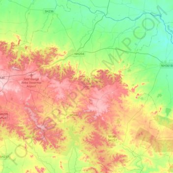
Name: Topografische Karte Kalamb, Höhe, Relief.
Ort: Kalamb, Yavatmal, Maharashtra, India (20.18524 78.20935 20.55586 78.51673)
Durchschnittliche Höhe: 322 m
Minimale Höhe: 214 m
Maximale Höhe: 469 m
Andere topografische Karten
Klicken Sie auf eine Karte, um ihre Topografie, ihre Höhe und ihr Relief anzuzeigen.
Kalaspur
India > Maharashtra > Kalamb
Kalaspur, Kalamb, Yavatmal, Maharashtra, 445401, India
Durchschnittliche Höhe: 249 m
Wadgaon J.
India > Maharashtra > Kalamb
Wadgaon J., Kalamb, Dharashiv, Maharashtra, 413405, India
Durchschnittliche Höhe: 674 m
Kalamb
India > Maharashtra > Kalamb
Kalamb, Osmanabad, Maharashtra, India
Durchschnittliche Höhe: 668 m
Manjara Dam
India > Maharashtra > Kalamb > Karanjakalla
Manjara Dam, Karanjakalla, Kalamb, Osmanabad, Maharashtra, India
Durchschnittliche Höhe: 650 m