
Topografische Karte Tongass National Forest
Interaktive Karte
Klicken Sie auf die Karte, um die Höhe anzuzeigen.
Über diese Karte
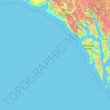
Name: Topografische Karte Tongass National Forest, Höhe, Relief.
Durchschnittliche Höhe: 156 m
Minimale Höhe: -4 m
Maximale Höhe: 4.094 m
Historically, logging operations tended to concentrate on lower-elevation, bigger-tree ecosystems for harvesting; at present, approximately 78% of the land remains intact, i.e. 383,000 acres (1,550 km2) out of 491,000 acres (1,990 km2) original big-tree, low-elevation forest area. Given the high value of these areas for wildlife species, close to 70% of this old growth forest is protected in reserves and will never be eligible for harvest.
Andere topografische Karten
Klicken Sie auf eine Karte, um ihre Topografie, ihre Höhe und ihr Relief anzuzeigen.
Clarence Kramer Peak
United States > Alaska > Sitka > Sitka
Clarence Kramer Peak, Sitka, Alaska, United States
Durchschnittliche Höhe: 751 m
North Sister
United States > Alaska > Sitka > Sitka
North Sister, Sitka, Alaska, United States
Durchschnittliche Höhe: 507 m
Beaver Lake
United States > Alaska > Sitka > Sitka
Beaver Lake, Sitka, Alaska, United States
Durchschnittliche Höhe: 313 m
Chatham
United States > Alaska > Sitka
Chatham, Sitka, Alaska, United States
Durchschnittliche Höhe: 127 m
Fleming Island
United States > Alaska > Sitka
Fleming Island, Sitka, Alaska, United States
Durchschnittliche Höhe: 149 m
Mount Edgecumbe
United States > Alaska > Sitka
Mount Edgecumbe, Sitka, Alaska, United States
Durchschnittliche Höhe: 597 m