
Topografische Karte Navi Mumbai
Interaktive Karte
Klicken Sie auf die Karte, um die Höhe anzuzeigen.
Über diese Karte
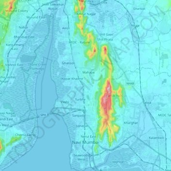
Name: Topografische Karte Navi Mumbai, Höhe, Relief.
Ort: Navi Mumbai, Thane, Thane District, Maharashtra, India (18.99845 72.97786 19.18947 73.04970)
Durchschnittliche Höhe: 22 m
Minimale Höhe: -3 m
Maximale Höhe: 395 m
Navi Mumbai (Marathi pronunciation: [nəʋiː mumbəiː]) is a planned city situated on the west coast of the Indian subcontinent, located in the Konkan division of Maharashtra state, on the mainland of India. Navi Mumbai is part of the Mumbai Metropolitan Region (MMR). The city is divided into two, North Navi Mumbai and South Navi Mumbai, for the individual development of Panvel Mega City, which includes the area from Kharghar to Uran, including the Taloja node. The Agri and Koli Communities mainly reside in Navi Mumbai. Navi Mumbai was the host city for the inaugural final of the IPL (2008) at DY Patil Stadium. Thane Belapur Marg and Palm Beach Marg are major business attraction and upmarket residential areas respectively. Navi Mumbai has a population of 1,119,477 as per the 2011 provisional census. It has an average city elevation of 14 meters, excluding forest area.
Andere topografische Karten
Klicken Sie auf eine Karte, um ihre Topografie, ihre Höhe und ihr Relief anzuzeigen.
Thane
India > Maharashtra > Thane
Thane, Thane District, Maharashtra, India
Durchschnittliche Höhe: 54 m
Pachwad
India > Maharashtra > Thane > Thane
Pachwad, Thane, Maharashtra, 400615, India
Durchschnittliche Höhe: 87 m
Belapur Fort
India > Maharashtra > Thane > Navi Mumbai
Belapur Fort, CIDCO Guest House Road, Belapur Village, Belapur West, Navi Mumbai, Thane, Maharashtra, 400614, India
Durchschnittliche Höhe: 4 m
Sector 13
India > Maharashtra > Thane > Navi Mumbai
Sector 13, Ghansoli, Navi Mumbai, Thane, Maharashtra, India
Durchschnittliche Höhe: 3 m
Thane
India > Maharashtra > Thane > Thane
Thane, Mumbai Metropolitan Region, Thane, Maharashtra, 400602, India
Durchschnittliche Höhe: 30 m