
Topografische Karte Marble Hill
Interaktive Karte
Klicken Sie auf die Karte, um die Höhe anzuzeigen.
Über diese Karte
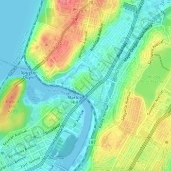
Name: Topografische Karte Marble Hill, Höhe, Relief.
Ort: Marble Hill, New York, United States of America (40.87140 -73.91838 40.88045 -73.90616)
Durchschnittliche Höhe: 27 m
Minimale Höhe: 0 m
Maximale Höhe: 75 m
Because of this change in topography, Marble Hill is often associated with the Bronx and is part of Bronx Community District 8. In addition, Marble Hill has a Bronx ZIP Code of 10463, and is served by the New York City Police Department's 50th Precinct, headquartered in the Bronx.
Andere topografische Karten
Klicken Sie auf eine Karte, um ihre Topografie, ihre Höhe und ihr Relief anzuzeigen.
Wave Hill
United States of America > New York > New York
Wave Hill, Riverdale, New York, The Bronx, Bronx County, New York, United States of America
Durchschnittliche Höhe: 25 m
WNYC-AM (New York)
United States of America > New York > New York
WNYC-AM (New York), 8, Greenpoint Avenue, Greenpoint, New York, Brooklyn, Kings County, New York, 11222, United States of America
Durchschnittliche Höhe: 4 m
Liggett Terrace
United States of America > New York > New York > Liggett Terrace
Liggett Terrace, Manhattan Community Board 1, Manhattan, New York County, New York, 10004, United States of America
Durchschnittliche Höhe: 3 m