
Topografische Karte XII.
Interaktive Karte
Klicken Sie auf die Karte, um die Höhe anzuzeigen.
Über diese Karte
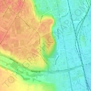
Name: Topografische Karte XII., Höhe, Relief.
Durchschnittliche Höhe: 218 m
Minimale Höhe: 195 m
Maximale Höhe: 246 m
Andere topografische Karten
Klicken Sie auf eine Karte, um ihre Topografie, ihre Höhe und ihr Relief anzuzeigen.
District of Košice IV
Slovakia > Region of Košice > District of Košice IV
District of Košice IV, Košice, Region of Košice, Eastern Slovakia, Slovakia
Durchschnittliche Höhe: 223 m
Južné Mesto
Slovakia > Region of Košice > District of Košice IV
Južné Mesto, Košice - mestská časť Juh, District of Košice IV, Košice, Region of Košice, Eastern Slovakia, 04001, Slovakia
Durchschnittliche Höhe: 223 m