
Topografische Karte Lake Como
Interaktive Karte
Klicken Sie auf die Karte, um die Höhe anzuzeigen.
Über diese Karte
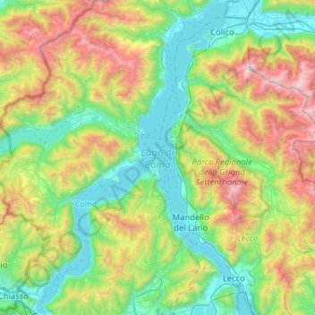
Name: Topografische Karte Lake Como, Höhe, Relief.
Ort: Lake Como, Como, Lombardy, Italy (45.81316 9.06673 46.17036 9.38897)
Durchschnittliche Höhe: 885 m
Minimale Höhe: 188 m
Maximale Höhe: 2.593 m
Lake Como weather is humid subtropical (Cfa in the Köppen climate classification). In the winter, the lake helps to maintain a higher temperature in the surrounding region. Average daily temperatures range from about 3.7 °C (39 °F) in January to 23.4 °C (74 °F) in July, according to historical weather data from Como. Water temperatures can reach an average of 24 °C (75 °F) during the month of July. Snowfall is erratic and primarily affects the higher elevations. Rainfall is heaviest in May and lowest during the winter months.
Andere topografische Karten
Klicken Sie auf eine Karte, um ihre Topografie, ihre Höhe und ihr Relief anzuzeigen.
Campione d'Italia
Campione d'Italia, Como, Lombardy, 22061, Italy
Durchschnittliche Höhe: 438 m
Panama Beach
Italy > Lombardy > Como > Tavordo
Panama Beach, Tavordo, Porlezza, Como, Lombardy, 22018, Italy
Durchschnittliche Höhe: 398 m
Lago di Piano
Italy > Lombardy > Como > Piano Porlezza > Castello
Lago di Piano, Castello, Piano Porlezza, Carlazzo, Como, Lombardy, Italy
Durchschnittliche Höhe: 420 m
San Fermo della Battaglia
San Fermo della Battaglia, Como, Lombardy, 22042, Italy
Durchschnittliche Höhe: 381 m