
Topografische Karte Opotiki
Interaktive Karte
Klicken Sie auf die Karte, um die Höhe anzuzeigen.
Über diese Karte
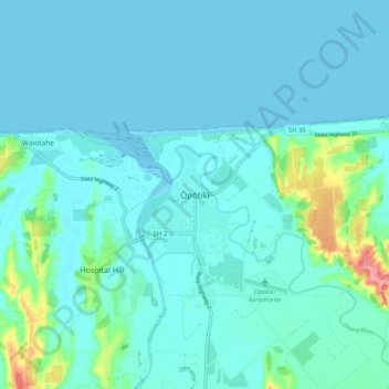
Name: Topografische Karte Opotiki, Höhe, Relief.
Durchschnittliche Höhe: 14 m
Minimale Höhe: 0 m
Maximale Höhe: 104 m
Andere topografische Karten
Klicken Sie auf eine Karte, um ihre Topografie, ihre Höhe und ihr Relief anzuzeigen.
Parinui
New Zealand > Bay of Plenty > Ōpōtiki District
Parinui, Ōpōtiki District, Bay of Plenty, 3162, New Zealand
Durchschnittliche Höhe: 67 m
Whitianga
New Zealand > Bay of Plenty > Ōpōtiki District
Whitianga, Ōpōtiki District, Bay of Plenty, 3162, New Zealand
Durchschnittliche Höhe: 42 m
Papamoa
New Zealand > Bay of Plenty > Ōpōtiki District
Papamoa, Ōpōtiki District, Bay of Plenty, New Zealand
Durchschnittliche Höhe: 544 m
Ohiwa
New Zealand > Bay of Plenty > Ōpōtiki District
Ohiwa, Ōpōtiki District, Bay of Plenty, 3198, New Zealand
Durchschnittliche Höhe: 11 m
Kaharoa
New Zealand > Bay of Plenty > Ōpōtiki District
Kaharoa, Ōpōtiki District, Bay of Plenty, New Zealand
Durchschnittliche Höhe: 721 m