
Spenden
Topografische Karte Sibuyan Island
Klicken Sie auf die Karte, um die Höhe anzuzeigen.
Spenden
Sibuyan Island
Sibuyan is a crescent-shaped island, the second largest in an archipelago comprising Romblon Province, Philippines. Located in the namesake Sibuyan Sea, it has an area of 445 square kilometres (172 sq mi) and has a total population of 62,815, as of the 2020 census. The island has two prominent peaks, the highest is Mount Guiting-Guiting, with an elevation of 2,058 metres (6,752 ft), followed by Mount Nailog, which is 789 metres (2,589 ft) high. The people speak the Sibuyanon dialect of Romblomanon, a Visayan language.
Spenden
Über diese Karte
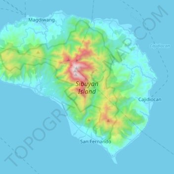
Name: Topografische Karte Sibuyan Island, Höhe, Relief.
Ort: Sibuyan Island, Romblon, Mimaropa, Philippines (12.26705 122.42342 12.50612 122.69900)
Durchschnittliche Höhe: 182 m
Minimale Höhe: -1 m
Maximale Höhe: 1.991 m
Spenden
Andere topografische Karten
Klicken Sie auf eine Karte, um ihre Topografie, ihre Höhe und ihr Relief anzuzeigen.