
Topografische Karte Rockport
Interaktive Karte
Klicken Sie auf die Karte, um die Höhe anzuzeigen.
Über diese Karte
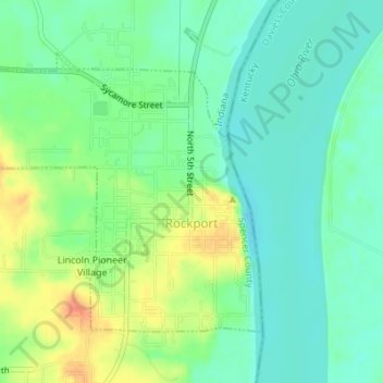
Name: Topografische Karte Rockport, Höhe, Relief.
Ort: Rockport, Spencer County, Indiana, United States (37.87542 -87.07115 37.89515 -87.04306)
Durchschnittliche Höhe: 121 m
Minimale Höhe: 104 m
Maximale Höhe: 151 m
Andere topografische Karten
Klicken Sie auf eine Karte, um ihre Topografie, ihre Höhe und ihr Relief anzuzeigen.
Rock Hill
United States > Indiana > Spencer County
Rock Hill, Spencer County, Indiana, United States
Durchschnittliche Höhe: 124 m
Dale
United States > Indiana > Spencer County
Dale, Spencer County, Indiana, United States
Durchschnittliche Höhe: 138 m
Santa Claus
United States > Indiana > Spencer County
Santa Claus, Spencer County, Indiana, 47579, United States
Durchschnittliche Höhe: 143 m
Ritchie
United States > Indiana > Spencer County > Ritchie
Ritchie, Spencer County, Indiana, 57611, United States
Durchschnittliche Höhe: 127 m