
Topografische Karte Nowy Targ County
Interaktive Karte
Klicken Sie auf die Karte, um die Höhe anzuzeigen.
Über diese Karte
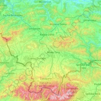
Name: Topografische Karte Nowy Targ County, Höhe, Relief.
Ort: Nowy Targ County, Lesser Poland Voivodeship, Poland (49.32641 19.52741 49.66112 20.61706)
Durchschnittliche Höhe: 757 m
Minimale Höhe: 241 m
Maximale Höhe: 2.601 m
Andere topografische Karten
Klicken Sie auf eine Karte, um ihre Topografie, ihre Höhe und ihr Relief anzuzeigen.
Libertów
Poland > Lesser Poland Voivodeship > Kraków County
Libertów, gmina Mogilany, Kraków County, Lesser Poland Voivodeship, 30-444, Poland
Durchschnittliche Höhe: 270 m
Krakow
Poland > Lesser Poland Voivodeship
Krakow, Lesser Poland Voivodeship, Poland
Durchschnittliche Höhe: 263 m
Limanowa
Poland > Lesser Poland Voivodeship > Limanowa
Limanowa, Limanowa County, Lesser Poland Voivodeship, Poland
Durchschnittliche Höhe: 490 m
Zakopane
Poland > Lesser Poland Voivodeship > Zakopane
Zakopane, Tatra County, Lesser Poland Voivodeship, Poland
Durchschnittliche Höhe: 1.180 m
Nowy Targ
Poland > Lesser Poland Voivodeship > Nowy Targ
Nowy Targ, powiat nowotarski, Lesser Poland Voivodeship, Poland
Durchschnittliche Höhe: 679 m