
Spenden
Topografische Karte Orient City
Klicken Sie auf die Karte, um die Höhe anzuzeigen.
Spenden
Über diese Karte
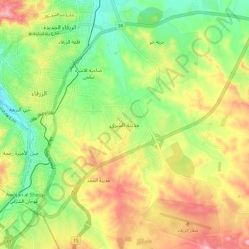
Name: Topografische Karte Orient City, Höhe, Relief.
Durchschnittliche Höhe: 619 m
Minimale Höhe: 546 m
Maximale Höhe: 707 m
Spenden
Andere topografische Karten
Klicken Sie auf eine Karte, um ihre Topografie, ihre Höhe und ihr Relief anzuzeigen.
Zarqa
Jordan > Zarqa > Zarqa Sub-District
Zarqa has a cold semi-arid climate (Köppen climate classification: BSk). The average annual temperature is 17.4 °C (63.3 °F), and around 182 mm (7.17 in) of precipitation falls annually, mostly in winter months. Zarqa's elevation is 619 meters above sea level.
Durchschnittliche Höhe: 617 m
Zarqa
Jordan > Zarqa > Zarqa Sub-District
Zarqa has a cold semi-arid climate (Köppen climate classification: BSk). The average annual temperature is 17.4 °C (63.3 °F), and around 182 mm (7.17 in) of precipitation falls annually, mostly in winter months. Zarqa's elevation is 619 meters above sea level, and the city occasionally receives snowfall in…
Durchschnittliche Höhe: 617 m