
Spenden
Topografische Karte Peel River
Klicken Sie auf die Karte, um die Höhe anzuzeigen.
Spenden
Über diese Karte
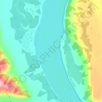
Name: Topografische Karte Peel River, Höhe, Relief.
Ort: Peel River, Inuvik Region, Northwest Territories, Canada (67.13883 -135.02793 67.13893 -135.02783)
Durchschnittliche Höhe: 45 m
Minimale Höhe: 0 m
Maximale Höhe: 184 m
Spenden
Andere topografische Karten
Klicken Sie auf eine Karte, um ihre Topografie, ihre Höhe und ihr Relief anzuzeigen.
Spenden
Spenden
Spenden
Spenden
Spenden
Thaidene Nene National Park Reserve Of Canada
Canada > Northwest Territories
Durchschnittliche Höhe: 382 m
Spenden
Grace Lake
Canada > Northwest Territories > North Slave Region > Yellowknife
Durchschnittliche Höhe: 180 m
Spenden
Spenden
Jackfish Lake
Canada > Northwest Territories > North Slave Region > Yellowknife
Durchschnittliche Höhe: 192 m
Spenden
Mackenzie River
Canada > Northwest Territories > Sahtu Region
The Mackenzie widens considerably to about 6 to 7 kilometres (3.7 to 4.3 mi) at Norman Wells, a major centre of oil production. There is a narrows at the Mountain River confluence called the Sans Sault Rapids, where the Mackenzie falls about 6 metres (20 ft). Below the Mountain River the Mackenzie flows due…
Durchschnittliche Höhe: 206 m
Spenden
Spenden
Jean Marie River
Canada > Northwest Territories > Dehcho Region > Jean Marie River
Durchschnittliche Höhe: 142 m
Behchokǫ̀
Canada > Northwest Territories > North Slave Region
As the community grew alongside increased services such as a mission-run hospital and church, the government viewed the topography of Fort Rae as unsuitable for expansion. In the 1950s there was concern about runoff from animal and human wastes contaminating sources of drinking water, and the government…
Durchschnittliche Höhe: 169 m
Spenden
Spenden
Inuvialuit Settlement Region
Canada > Northwest Territories > Inuvik Region
Durchschnittliche Höhe: 69 m
Spenden
Spenden
Spenden
Mackenzie River
Canada > Northwest Territories > Sahtu Region
The Mackenzie widens considerably to about 6 to 7 kilometres (3.7 to 4.3 mi) at Norman Wells, a major centre of oil production. There is a narrows at the Mountain River confluence called the Sans Sault Rapids, where the Mackenzie falls about 6 metres (20 ft). Below the Mountain River the Mackenzie flows due…
Durchschnittliche Höhe: 97 m
Spenden
Spenden