
Vielen Dank für die Unterstützung dieser Website ❤️
Spenden
Spenden
Topografische Karte Koyilandy
Klicken Sie auf die Karte, um die Höhe anzuzeigen.
Vielen Dank für die Unterstützung dieser Website ❤️
Spenden
Spenden
Koyilandy
Koyilandy is located at 11°26′N 75°42′E / 11.43°N 75.70°E / 11.43; 75.70 at an average elevation of 2 m (6.6 ft).
Vielen Dank für die Unterstützung dieser Website ❤️
Spenden
Spenden
Über diese Karte
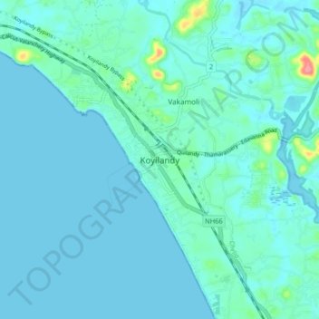
Name: Topografische Karte Koyilandy, Höhe, Relief.
Ort: Koyilandy, Koyilandi, Kozhikode, Kerala, 673300, India (11.39836 75.65689 11.47836 75.73689)
Durchschnittliche Höhe: 9 m
Minimale Höhe: -2 m
Maximale Höhe: 84 m
Vielen Dank für die Unterstützung dieser Website ❤️
Spenden
Spenden
Andere topografische Karten
Klicken Sie auf eine Karte, um ihre Topografie, ihre Höhe und ihr Relief anzuzeigen.
Alangattu Vettkkoru makan kshethra Kulam at Cheliya
Durchschnittliche Höhe: 13 m
Vielen Dank für die Unterstützung dieser Website ❤️
Spenden
Spenden
Vielen Dank für die Unterstützung dieser Website ❤️
Spenden
Spenden