
Topografische Karte Srinagar
Klicken Sie auf die Karte, um die Höhe anzuzeigen.
Srinagar
Srinagar is located at 30°13′N 78°47′E / 30.22°N 78.78°E / 30.22; 78.78. at the left bank of Alaknanda river. It has an average elevation of 560 metres (1,837 feet). It is the largest town in the Garhwal Hills. It is reached by national highway NH58 from Rishikesh, Srinagar is about 104 km from Rishikesh which is the last city on the plains of Uttarakhand and from where the mountains start. Srinagar can also be reached via Kotdwara, from Kotdwara it takes maximum 5 hours to reach there.It is a municipal board in the Pauri district of uttarakhand which is now upgraded to Municipal Corporation recently.
Über diese Karte
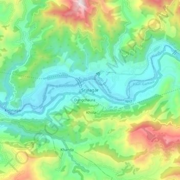
Name: Topografische Karte Srinagar, Höhe, Relief.
Ort: Srinagar, Pauri Garhwal, Uttarakhand, 249127, India (30.18381 78.74790 30.26381 78.82790)
Durchschnittliche Höhe: 859 m
Minimale Höhe: 512 m
Maximale Höhe: 1.668 m
Andere topografische Karten
Klicken Sie auf eine Karte, um ihre Topografie, ihre Höhe und ihr Relief anzuzeigen.