
Topografische Karte Cephalonia
Interaktive Karte
Klicken Sie auf die Karte, um die Höhe anzuzeigen.
Über diese Karte
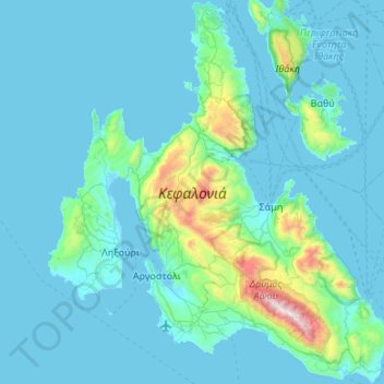
Name: Topografische Karte Cephalonia, Höhe, Relief.
Durchschnittliche Höhe: 138 m
Minimale Höhe: -2 m
Maximale Höhe: 1.601 m
The island's highest mountain is Mount Ainos, with an elevation of 1628 meters; to the west-northwest are the Paliki mountains, where Lixouri is found, with other mountains including Geraneia (Gerania) and Agia Dynati. The top of Mount Ainos is covered with fir trees and is a natural park.
Andere topografische Karten
Klicken Sie auf eine Karte, um ihre Topografie, ihre Höhe und ihr Relief anzuzeigen.
Kefalonia
Greece > Peloponnese, Western Greece and the Ionian > Kefallonia Regional Unit
Kefalonia, Argostoli Municipality, Kefallonia Regional Unit, Ioanian Islands, Peloponnese, Western Greece and the Ionian, Greece
Durchschnittliche Höhe: 60 m
Pastra
Greece > Peloponnese, Western Greece and the Ionian > Kefallonia Regional Unit > Municipal Unit of Elios-Proni
Pastra, Municipal Unit of Elios-Proni, Argostoli Municipality, Kefallonia Regional Unit, Ioanian Islands, Peloponnese, Western Greece and the Ionian, 280 82, Greece
Durchschnittliche Höhe: 305 m
Argostoli
Greece > Peloponnese, Western Greece and the Ionian > Kefallonia Regional Unit
Argostoli, Argostoli Municipality, Kefallonia Regional Unit, Ioanian Islands, Peloponnese, Western Greece and the Ionian, 281 00, Greece
Durchschnittliche Höhe: 79 m
Katelios
Greece > Peloponnese, Western Greece and the Ionian > Kefallonia Regional Unit > Municipal Unit of Elios-Proni > Kato Katelios > Katelios
Katelios, Kato Katelios, Municipal Unit of Elios-Proni, Argostoli Municipality, Kefallonia Regional Unit, Ioanian Islands, Peloponnese, Western Greece and the Ionian, 28082, Greece
Durchschnittliche Höhe: 180 m
Sami
Greece > Peloponnese, Western Greece and the Ionian > Kefallonia Regional Unit > Sami Municipal Unit
Sami, Sami Municipal Unit, Sami Municipality, Kefallonia Regional Unit, Ioanian Islands, Peloponnese, Western Greece and the Ionian, 280 80, Greece
Durchschnittliche Höhe: 200 m