
Spenden
Topografische Karte Santa Maria
Klicken Sie auf die Karte, um die Höhe anzuzeigen.
Spenden
Santa Maria
The topography of Santa Maria is generally flat, however, it is becoming hilly towards the north. This area covers the barangays of Silangan, Mag-asawang Sapa, Pulong Buhangin and some parts of Balasing with landscape ranging from 8 to 18 percent slope. The rest of the barangays have a slope range from level to undulating.
Spenden
Über diese Karte
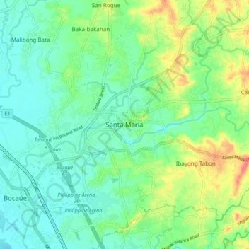
Name: Topografische Karte Santa Maria, Höhe, Relief.
Ort: Santa Maria, Bulacan, Central Luzon, 3022, Philippines (14.77918 120.92175 14.85918 121.00175)
Durchschnittliche Höhe: 18 m
Minimale Höhe: 0 m
Maximale Höhe: 55 m
Spenden
Andere topografische Karten
Klicken Sie auf eine Karte, um ihre Topografie, ihre Höhe und ihr Relief anzuzeigen.
Marina Lake
Philippines > Bulacan > San Jose del Monte > Sapang Palay Proper
Durchschnittliche Höhe: 50 m
Biak na Bato National Park
Philippines > Bulacan > Doña Remedios Trinidad > Talbak
Durchschnittliche Höhe: 127 m
Spenden
Doña Remedios Trinidad
List of highest peaks in D.R.T by elevation.
Durchschnittliche Höhe: 172 m