
Topografische Karte Asind
Klicken Sie auf die Karte, um die Höhe anzuzeigen.
Asind
Asind is located at 25°44′N 74°20′E / 25.73°N 74.33°E / 25.73; 74.33. It has an average elevation of 467 metres (1532 feet). Asind is also the name of a Chinese Company located in Hangzhou, Zhejiang Province of China. Mines is Located in Village Shambhugarh, Daultgarh, Roop-pura, Barana, Tehsil Asind, District Bhilwara in Rajasthan of Soda Feldspar Quartz and mica. Tehsil Asind district Bhilwara, Rajasthan. This mine is enriched with one India's unique mineral deposit of Potassium feldspar, Quartz and mica and can meet any quantity at very short span of period. The joint capacity of both of these mines is around 150000 tons of mineral per annum. In Asind there is many mines for Stone which is used to make Houses and buildings in many areas of Rajasthan.
Über diese Karte
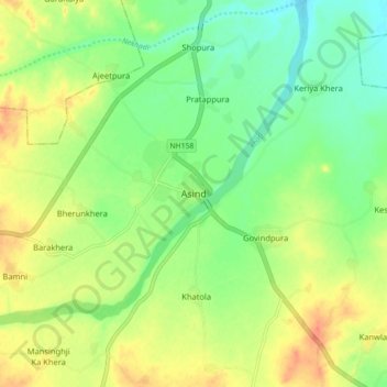
Name: Topografische Karte Asind, Höhe, Relief.
Durchschnittliche Höhe: 479 m
Minimale Höhe: 459 m
Maximale Höhe: 502 m