
Topografische Karte Malpas
Interaktive Karte
Klicken Sie auf die Karte, um die Höhe anzuzeigen.
Über diese Karte
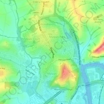
Name: Topografische Karte Malpas, Höhe, Relief.
Ort: Malpas, Newport, Gwent, Wales, United Kingdom (51.60404 -3.01994 51.62145 -2.99069)
Durchschnittliche Höhe: 30 m
Minimale Höhe: 0 m
Maximale Höhe: 93 m
Andere topografische Karten
Klicken Sie auf eine Karte, um ihre Topografie, ihre Höhe und ihr Relief anzuzeigen.
Monmouthshire Canal Crumlin Branch
United Kingdom > Wales > Gwent > Newport
Monmouthshire Canal Crumlin Branch, Barrack Hill, Allt-Yr-Yn, Newport, Gwent, Wales, NP20 5EH, United Kingdom
Durchschnittliche Höhe: 40 m
Monmouthshire Canal Crumlin Branch
United Kingdom > Wales > Gwent > Newport
Monmouthshire Canal Crumlin Branch, Ridgeway, Allt-Yr-Yn, Newport, Gwent, Wales, NP20 5DX, United Kingdom
Durchschnittliche Höhe: 43 m
Parc Seymour
United Kingdom > Wales > Gwent > Newport
Parc Seymour, Penhow, Newport, Gwent, Wales, NP26 3AB, United Kingdom
Durchschnittliche Höhe: 107 m
Underwood
United Kingdom > Wales > Gwent > Newport
Underwood, Newport, Gwent, Wales, NP18 2HQ, United Kingdom
Durchschnittliche Höhe: 38 m
Rhiwderin
United Kingdom > Wales > Gwent > Newport
Rhiwderin, Newport, Gwent, Wales, NP10 8RN, United Kingdom
Durchschnittliche Höhe: 73 m