
Topografische Karte Muvattupuzha
Klicken Sie auf die Karte, um die Höhe anzuzeigen.
Muvattupuzha
The town and western parts of the region are mainly plains and is culturally similar to Ernakulam, whereas the eastern parts are mainly highlands. The regions of Thodupuzha, Muvattupuzha, and Kothamangalam are called sub-high ranges or keezhmalanad of Vadakkumkoor Kingdom, indicating they were lands with fertile soil deposited by the Thodupuzha and Muvattupuzha rivers from flooding. Muvattupuzha and nearby areas are less hilly and fertile. The altitude is lower and the hilly region is the Kadalikkad-Meenkunnam-Pampakkuda curved region. The town is 20 m (66 ft) above mean sea level.
Über diese Karte
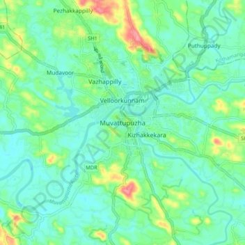
Name: Topografische Karte Muvattupuzha, Höhe, Relief.
Ort: Muvattupuzha, Ernakulam, Kerala, 686661, India (9.82315 76.41816 10.14315 76.73816)
Durchschnittliche Höhe: 44 m
Minimale Höhe: 0 m
Maximale Höhe: 603 m