
Topografische Karte Great Salt Lake
Interaktive Karte
Klicken Sie auf die Karte, um die Höhe anzuzeigen.
Über diese Karte
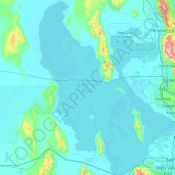
Name: Topografische Karte Great Salt Lake, Höhe, Relief.
Ort: Great Salt Lake, Box Elder County, Utah, USA (40.66900 -113.10122 41.70498 -111.93021)
Durchschnittliche Höhe: 1.380 m
Minimale Höhe: 1.277 m
Maximale Höhe: 2.919 m
Andere topografische Karten
Klicken Sie auf eine Karte, um ihre Topografie, ihre Höhe und ihr Relief anzuzeigen.
Timpanogos Glacier
USA > Utah > Aspen Grove
Timpanogos Glacier, Mount Timpanogos Trail #052, Aspen Grove, Utah County, Utah, USA
Durchschnittliche Höhe: 3.148 m
La Sal Mountains Viewpoint
La Sal Mountains Viewpoint, Arches Entrance Road, Grand County, Utah, 84532-2134, USA
Durchschnittliche Höhe: 1.347 m