
Topografische Karte Nathu La
Interaktive Karte
Klicken Sie auf die Karte, um die Höhe anzuzeigen.
Nathu La
Nathu La is a mountain pass on the Dongkya Range that separates Sikkim and the Chumbi Valley at an elevation of 14,250 feet (4,340 m). The pass is 52–54 kilometres (32–34 mi) east of Gangtok, the capital of Sikkim, and 35 kilometres (22 mi) from Yatung Shasima, the headquarters of the Yadong County (or the Chumbi Valley).
Über diese Karte
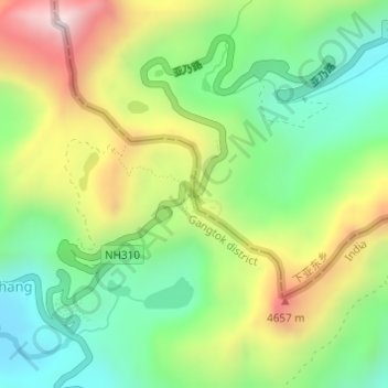
Name: Topografische Karte Nathu La, Höhe, Relief.
Durchschnittliche Höhe: 4.240 m
Minimale Höhe: 3.938 m
Maximale Höhe: 4.703 m
Andere topografische Karten
Klicken Sie auf eine Karte, um ihre Topografie, ihre Höhe und ihr Relief anzuzeigen.
Doklam
China > Tibet > Yadong County > Xiayadong
Through this exploration, Bell discovered that the prevailing border between Bhutan and Tibet to the west of Amo Chu was a highland tree (Ya-shing) – lowland tree (Mön-shing) border over the same geographic region. The highland trees belonged to Tibet, perhaps above 11,500 ft in elevation, while the lowland…
Durchschnittliche Höhe: 3.192 m