Geolokalisieren
👉 Easily get elevation data in JSON, GeoTIFF and KML formats using Elevation API
Vielen Dank für die Unterstützung dieser Website ❤️
Spenden

Topografische Karte Hatch

Klicken Sie auf die Karte, um die Höhe anzuzeigen.

👉 Easily get elevation data in JSON, GeoTIFF and KML formats using Elevation API
Vielen Dank für die Unterstützung dieser Website ❤️
Spenden

Über diese Karte

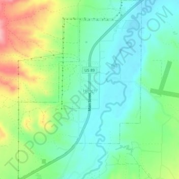
Name: Topografische Karte Hatch, Höhe, Relief.

Ort: Hatch, Garfield County, Utah, 84735, United States (37.63393 -112.45056 37.66585 -112.42272)

Durchschnittliche Höhe: 2.135 m

Minimale Höhe: 2.091 m

Maximale Höhe: 2.227 m

👉 Easily get elevation data in JSON, GeoTIFF and KML formats using Elevation API
Vielen Dank für die Unterstützung dieser Website ❤️
Spenden

Andere topografische Karten

Klicken Sie auf eine Karte, um ihre Topografie, ihre Höhe und ihr Relief anzuzeigen.

Panguitch Lake

United States > Utah > Garfield County

Durchschnittliche Höhe: 2.528 m

Mount Ellen

United States > Utah > Garfield County

Mount Ellen is an ultra prominent peak, meaning that it has more than 1,500 metres (4,921 ft) of topographic prominence, standing out considerably from nearby mountains. It stands in the watershed of the Fremont River, which together with Muddy Creek forms the Dirty Devil River, which drains into the Colorado…

Durchschnittliche Höhe: 3.149 m

Mount Hillers

United States > Utah > Garfield County

Durchschnittliche Höhe: 2.934 m

Henry Mountains

United States > Utah > Garfield County

Durchschnittliche Höhe: 1.936 m

Vielen Dank für die Unterstützung dieser Website ❤️
Spenden

Bryce Canyon

United States > Utah > Garfield County > Tropic

Durchschnittliche Höhe: 2.247 m

Bryce Canyon

United States > Utah > Garfield County > Tropic

Durchschnittliche Höhe: 2.246 m

Bryce Canyon

United States > Utah > Garfield County > Tropic

Durchschnittliche Höhe: 2.246 m

Bryce Canyon

United States > Utah > Garfield County > Tropic

Durchschnittliche Höhe: 2.247 m

Vielen Dank für die Unterstützung dieser Website ❤️
Spenden

Henry Mountains

United States > Utah > Garfield County

Durchschnittliche Höhe: 1.936 m

Mount Ogden

United States > Utah > Garfield County

Durchschnittliche Höhe: 2.226 m

Bryce Canyon

United States > Utah > Garfield County > Tropic

Durchschnittliche Höhe: 2.247 m