
Topografische Karte Puliyur
Klicken Sie auf die Karte, um die Höhe anzuzeigen.
Über diese Karte
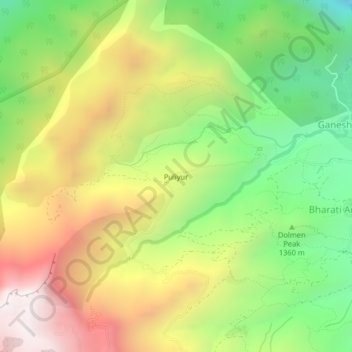
Name: Topografische Karte Puliyur, Höhe, Relief.
Ort: Puliyur, Kodaikanal, Dindigul, Tamil Nadu, India (10.28421 77.48021 10.32421 77.52021)
Durchschnittliche Höhe: 1.480 m
Minimale Höhe: 816 m
Maximale Höhe: 2.257 m
Andere topografische Karten
Klicken Sie auf eine Karte, um ihre Topografie, ihre Höhe und ihr Relief anzuzeigen.
Kodaikanal
India > Tamil Nadu > Kodaikanal
Kodaikanal has a monsoon-influenced subtropical highland climate (Cfb, according to the Köppen climate classification, with a Cwb tendency). The temperatures are cool throughout the year due to the high elevation of the city.
Durchschnittliche Höhe: 1.958 m
Kodaikanal Solar Observatory
India > Tamil Nadu > Kodaikanal > Kodaikanal
Durchschnittliche Höhe: 2.238 m
Kodaikanal
India > Tamil Nadu > Kodaikanal
Kodaikanal (Tamil: [ko'ɖaɪ'kaːnəl]) (English: ko-DYE-KAH-null) is a town and hill station in Dindigul district in the state of Tamil Nadu, India. It is situated at an altitude of 2,225 m (7,300 ft) in the Palani hills of the Western Ghats. Kodaikanal was established in 1845 to serve as a refuge from the…
Durchschnittliche Höhe: 1.976 m
Kodaikanal
India > Tamil Nadu > Kodaikanal
Kodaikanal (Tamil: [ko'ɖaɪ'kaːnəl]) (English: ko-DYE-KAH-null) is a municipality and hill station in Dindigul district in the state of Tamil Nadu, India. It is situated at an altitude of 2,225 m (7,300 ft) in the Palani hills of the Western Ghats. Kodaikanal was established in 1845 to serve as a refuge…
Durchschnittliche Höhe: 1.976 m