
Topografische Karte Waterford City Metropolitan District
Interaktive Karte
Klicken Sie auf die Karte, um die Höhe anzuzeigen.
Über diese Karte
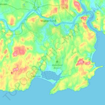
Name: Topografische Karte Waterford City Metropolitan District, Höhe, Relief.
Durchschnittliche Höhe: 29 m
Minimale Höhe: -5 m
Maximale Höhe: 128 m
Andere topografische Karten
Klicken Sie auf eine Karte, um ihre Topografie, ihre Höhe und ihr Relief anzuzeigen.
Ballyduff
Ballyduff, The Municipal District of Dungarvan — Lismore, Comté de Waterford, Munster, Irlande
Durchschnittliche Höhe: 187 m
The Municipal District of Dungarvan — Lismore
The Municipal District of Dungarvan — Lismore, Comté de Waterford, Munster, Irlande
Durchschnittliche Höhe: 120 m
Native Woodland Trust:Grace Dieu Reserve
Native Woodland Trust:Grace Dieu Reserve, Gracedieu, Waterford City Metropolitan District, Comté de Waterford, Munster, Irlande
Durchschnittliche Höhe: 27 m
Waterford
Waterford, Comté de Waterford, Munster, Irlande
Durchschnittliche Höhe: 33 m
Dungarvan
Dungarvan, The Municipal District of Dungarvan — Lismore, Comté de Waterford, Munster, X35 V670, Irlande
Durchschnittliche Höhe: 30 m