Geolokalisieren
👉 Easily get elevation data in JSON, GeoTIFF and KML formats using Elevation API
Vielen Dank für die Unterstützung dieser Website ❤️
Spenden

Topografische Karte Butte Lake

Klicken Sie auf die Karte, um die Höhe anzuzeigen.

👉 Easily get elevation data in JSON, GeoTIFF and KML formats using Elevation API
Vielen Dank für die Unterstützung dieser Website ❤️
Spenden

Über diese Karte

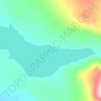
Name: Topografische Karte Butte Lake, Höhe, Relief.

Ort: Butte Lake, Stikine Region, British Columbia, Canada (59.13503 -130.64528 59.15163 -130.58468)

Durchschnittliche Höhe: 1.346 m

Minimale Höhe: 1.260 m

Maximale Höhe: 1.640 m

👉 Easily get elevation data in JSON, GeoTIFF and KML formats using Elevation API
Vielen Dank für die Unterstützung dieser Website ❤️
Spenden

Andere topografische Karten

Klicken Sie auf eine Karte, um ihre Topografie, ihre Höhe und ihr Relief anzuzeigen.

Gun Lake

Canada > British Columbia > Stikine Region

Durchschnittliche Höhe: 868 m

Good Hope Lake

Canada > British Columbia > Stikine Region

Durchschnittliche Höhe: 999 m

Atlin

Canada > British Columbia > Stikine Region

Durchschnittliche Höhe: 697 m

Cariboo Heart Range

Canada > British Columbia > Stikine Region

Durchschnittliche Höhe: 1.149 m

Vielen Dank für die Unterstützung dieser Website ❤️
Spenden

Blue River

Canada > British Columbia > Stikine Region

Durchschnittliche Höhe: 1.198 m

Liard River

Canada > British Columbia > Stikine Region > Lower Post

Durchschnittliche Höhe: 669 m

Tulsequah

Canada > British Columbia > Stikine Region

Durchschnittliche Höhe: 231 m

Tweedsmuir Glacier

Canada > British Columbia > Stikine Region

Durchschnittliche Höhe: 1.161 m

Vielen Dank für die Unterstützung dieser Website ❤️
Spenden

Llewellyn Glacier

Canada > British Columbia > Stikine Region

Durchschnittliche Höhe: 881 m

Tulsequah Glacier

Canada > British Columbia > Stikine Region

Durchschnittliche Höhe: 712 m

Heart Peaks

Canada > British Columbia > Stikine Region

Durchschnittliche Höhe: 1.792 m

Cracker Creek Cone

Canada > British Columbia > Stikine Region

Durchschnittliche Höhe: 1.356 m

Vielen Dank für die Unterstützung dieser Website ❤️
Spenden

Teslin Lake

Canada > British Columbia > Stikine Region

Durchschnittliche Höhe: 1.084 m

Rapid River

Canada > British Columbia > Stikine Region

Durchschnittliche Höhe: 1.307 m

Omineca Mountains

Canada > British Columbia > Stikine Region

Durchschnittliche Höhe: 1.674 m

White Pass

Canada > British Columbia > Stikine Region

White Pass, also known as the Dead Horse Trail (elevation 873 m or 2,864 ft), is a mountain pass through the Boundary Ranges of the Coast Mountains on the border of the U.S. state of Alaska and the province of British Columbia, Canada. It leads from Skagway, Alaska, to the chain of lakes at the headwaters of…

Durchschnittliche Höhe: 968 m

Vielen Dank für die Unterstützung dieser Website ❤️
Spenden

Nakina Lake

Canada > British Columbia > Stikine Region

Durchschnittliche Höhe: 1.147 m

Atlin

Canada > British Columbia > Stikine Region

Durchschnittliche Höhe: 697 m