
Topografische Karte Bel Aire
Interaktive Karte
Klicken Sie auf die Karte, um die Höhe anzuzeigen.
Über diese Karte
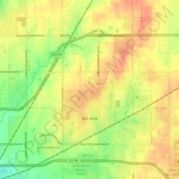
Name: Topografische Karte Bel Aire, Höhe, Relief.
Ort: Bel Aire, Sedgwick County, Kansas, United States (37.75229 -97.28077 37.79596 -97.18976)
Durchschnittliche Höhe: 424 m
Minimale Höhe: 396 m
Maximale Höhe: 444 m
Bel Aire is located at 37°45′50″N 97°15′58″W / 37.76389°N 97.26611°W / 37.76389; -97.26611 (37.763758, −97.266177) at an elevation of 1,394 feet (425 m). It lies on the north side of the East Fork of Chisholm Creek roughly 6 mi (9.7 km) northeast of the Arkansas River in the Wellington-McPherson Lowlands region of the Great Plains. Located on the south side of K-254 in south-central Kansas, Bel Aire is within the Wichita metropolitan area, bordered by Wichita to the south and west and bordered by Kechi to the north.
Andere topografische Karten
Klicken Sie auf eine Karte, um ihre Topografie, ihre Höhe und ihr Relief anzuzeigen.
Wichita
United States > Kansas > Sedgwick County
Wichita, Sedgwick County, Kansas, United States
Durchschnittliche Höhe: 408 m
Colwich
United States > Kansas > Sedgwick County
Colwich, Sedgwick County, Kansas, United States
Durchschnittliche Höhe: 421 m
Mulvane
United States > Kansas > Sedgwick County
Mulvane, Sedgwick County, Kansas, 67110, United States
Durchschnittliche Höhe: 386 m
Wichita
United States > Kansas > Sedgwick County > Wichita
Wichita, Sedgwick County, Kansas, 67202, United States
Durchschnittliche Höhe: 410 m
Andale
United States > Kansas > Sedgwick County
Andale, Sedgwick County, Kansas, United States
Durchschnittliche Höhe: 440 m
Kechi
United States > Kansas > Sedgwick County
Kechi, Sedgwick County, Kansas, United States
Durchschnittliche Höhe: 429 m
Garden Plain
United States > Kansas > Sedgwick County
Garden Plain, Sedgwick County, Kansas, United States
Durchschnittliche Höhe: 444 m
Maize
United States > Kansas > Sedgwick County
Maize, Sedgwick County, Kansas, United States
Durchschnittliche Höhe: 414 m
Valley Center
United States > Kansas > Sedgwick County
Valley Center, Sedgwick County, Kansas, United States
Durchschnittliche Höhe: 413 m
Park City
United States > Kansas > Sedgwick County
Park City, Sedgwick County, Kansas, United States
Durchschnittliche Höhe: 421 m
Haysville
United States > Kansas > Sedgwick County
Haysville, Riverside Township, Sedgwick County, Kansas, United States
Durchschnittliche Höhe: 388 m
Minneha
United States > Kansas > Sedgwick County > Wichita
Minneha, Wichita, Sedgwick County, Kansas, 67206, United States
Durchschnittliche Höhe: 423 m
Valley Center
United States > Kansas > Sedgwick County > Valley Center > Valley Center
Valley Center, Sedgwick County, Kansas, United States
Durchschnittliche Höhe: 415 m
Derby
United States > Kansas > Sedgwick County
Derby, Sedgwick County, Kansas, 67037, United States
Durchschnittliche Höhe: 393 m
Mount Hope
United States > Kansas > Sedgwick County > Mount Hope
Mount Hope, Sedgwick County, Kansas, United States
Durchschnittliche Höhe: 439 m