
Topografische Karte Mountain Zebra National Park
Interaktive Karte
Klicken Sie auf die Karte, um die Höhe anzuzeigen.
Über diese Karte
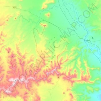
Name: Topografische Karte Mountain Zebra National Park, Höhe, Relief.
Durchschnittliche Höhe: 1.230 m
Minimale Höhe: 831 m
Maximale Höhe: 2.011 m
Andere topografische Karten
Klicken Sie auf eine Karte, um ihre Topografie, ihre Höhe und ihr Relief anzuzeigen.
Groot-Brakrivier
RSA > Eastern Cape > Inxuba Yethemba Local Municipality
Groot-Brakrivier, Inxuba Yethemba Local Municipality, Chris Hani District Municipality, Eastern Cape, RSA
Durchschnittliche Höhe: 1.351 m
Great Fish River
RSA > Eastern Cape > Inxuba Yethemba Local Municipality
Great Fish River, Inxuba Yethemba Local Municipality, Chris Hani District Municipality, Eastern Cape, RSA
Durchschnittliche Höhe: 1.248 m
Grassridge Dam
RSA > Eastern Cape > Inxuba Yethemba Local Municipality
Grassridge Dam, Inxuba Yethemba Ward 6, Inxuba Yethemba Local Municipality, Chris Hani District Municipality, Eastern Cape, RSA
Durchschnittliche Höhe: 1.059 m
Compassberg
RSA > Eastern Cape > Inxuba Yethemba Local Municipality
Compassberg, Inxuba Yethemba Local Municipality, Chris Hani District Municipality, Eastern Cape, RSA
Durchschnittliche Höhe: 2.017 m