
Topografische Karte Oron
Interaktive Karte
Klicken Sie auf die Karte, um die Höhe anzuzeigen.
Über diese Karte
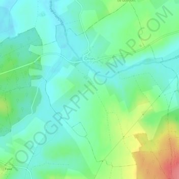
Name: Topografische Karte Oron, Höhe, Relief.
Durchschnittliche Höhe: 254 m
Minimale Höhe: 231 m
Maximale Höhe: 312 m
Andere topografische Karten
Klicken Sie auf eine Karte, um ihre Topografie, ihre Höhe und ihr Relief anzuzeigen.
Sarrebourg
Sarrebourg, Sarrebourg-Château-Salins, Moselle, Grand Est, France métropolitaine, 57400, France
Durchschnittliche Höhe: 273 m
Gondrexange
Gondrexange, Sarrebourg-Château-Salins, Moselle, Grand Est, France métropolitaine, 57815, France
Durchschnittliche Höhe: 286 m
Sentier du Moulin
France > Grand Est > Moselle > Pagny-lès-Goin
Sentier du Moulin, Pagny-lès-Goin, Metz, Moselle, Grand Est, France métropolitaine, 57420, France
Durchschnittliche Höhe: 234 m
Plappeville
Plappeville, Metz, Moselle, Grand Est, France métropolitaine, 57050, France
Durchschnittliche Höhe: 260 m
Volmerange-les-Mines
Volmerange-les-Mines, Thionville, Moselle, Grand Est, France métropolitaine, 57330, France
Durchschnittliche Höhe: 350 m
Prévocourt
Prévocourt, Sarrebourg-Château-Salins, Moselle, Grand Est, France métropolitaine, 57590, France
Durchschnittliche Höhe: 266 m
Saint-Georges
Saint-Georges, Sarrebourg-Château-Salins, Moselle, Grand Est, France métropolitaine, 57830, France
Durchschnittliche Höhe: 306 m
Saint-Hubert
Saint-Hubert, Metz, Moselle, Grand Est, France métropolitaine, 57640, France
Durchschnittliche Höhe: 261 m
Ars-sur-Moselle
Ars-sur-Moselle, Metz, Moselle, Grand Est, France métropolitaine, 57130, France
Durchschnittliche Höhe: 244 m
Moulins-lès-Metz
Moulins-lès-Metz, Metz, Moselle, Grand Est, France métropolitaine, 57160, France
Durchschnittliche Höhe: 178 m