
Spenden
Topografische Karte Antony
Klicken Sie auf die Karte, um die Höhe anzuzeigen.
Spenden
Antony
Antony is a city in the southern suburbs of Paris in the Hurepoix and is the chief town of the arrondissement of Hauts-de-Seine - 12.2 km south of Notre-Dame Cathedral. Its altitude is 48m above sea level at the lowest point at rue Gabriel Chamon in the Bièvre Valley and 100m at the highest point in the Avenue d'Estienne d'Orves on the border with Châtenay-Malabry. Antony is at the intersection of three departments.
Spenden
Über diese Karte
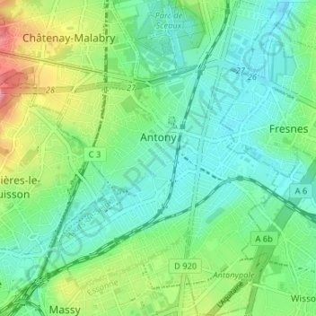
Name: Topografische Karte Antony, Höhe, Relief.
Durchschnittliche Höhe: 76 m
Minimale Höhe: 46 m
Maximale Höhe: 150 m
Spenden
Andere topografische Karten
Klicken Sie auf eine Karte, um ihre Topografie, ihre Höhe und ihr Relief anzuzeigen.
Résidence Beausoleil
France > Ile-de-France > Hauts-de-Seine > Saint-Cloud
Durchschnittliche Höhe: 78 m
Résidence Parc de Béarn
France > Ile-de-France > Hauts-de-Seine > Saint-Cloud
Durchschnittliche Höhe: 71 m
Spenden
Parc de Billancourt
France > Ile-de-France > Hauts-de-Seine > Boulogne-Billancourt
Durchschnittliche Höhe: 58 m
Val Saint-Olaf
France > Ile-de-France > Hauts-de-Seine > Chaville > Val Saint-Olaf
Durchschnittliche Höhe: 128 m