
Topografische Karte John Day Fossil Beds National Monument
Interaktive Karte
Klicken Sie auf die Karte, um die Höhe anzuzeigen.
Über diese Karte
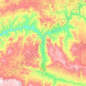
Name: Topografische Karte John Day Fossil Beds National Monument, Höhe, Relief.
Durchschnittliche Höhe: 1.136 m
Minimale Höhe: 500 m
Maximale Höhe: 1.922 m
Andere topografische Karten
Klicken Sie auf eine Karte, um ihre Topografie, ihre Höhe und ihr Relief anzuzeigen.
Happy Valley
USA > Oregon > Happy Valley
Happy Valley, Clackamas County, Oregon, 97086, USA
Durchschnittliche Höhe: 125 m
Ochoco National Forest
Ochoco National Forest, Maury Road, Crook County, Oregon, USA
Durchschnittliche Höhe: 1.303 m
Umatilla National Forest
Umatilla National Forest, National Forest Development Road 6415, Wallowa County, Oregon, USA
Durchschnittliche Höhe: 1.035 m
Siletz Bay
USA > Oregon > Lincoln City
Siletz Bay, Southwest Fleet Avenue, Cutler City, Lincoln City, Lincoln County, Oregon, 97367, USA
Durchschnittliche Höhe: 5 m
Deschutes National Forest
Deschutes National Forest, Mount Bachelor Loop, Deschutes County, Oregon, USA
Durchschnittliche Höhe: 1.249 m
Siuslaw National Forest
Siuslaw National Forest, National Forest Development Road 23, Douglas County, Oregon, USA
Durchschnittliche Höhe: 164 m
Eastmoreland
Eastmoreland, Portland, Multnomah County, Oregon, 97202, USA
Durchschnittliche Höhe: 42 m
Hells Canyon National Recreation Area
Hells Canyon National Recreation Area, Wallowa County, Oregon, USA
Durchschnittliche Höhe: 1.444 m
Cooper Mountain Nature Park
Cooper Mountain Nature Park, Hazeldale, Kinton, Washington County, Oregon, USA
Durchschnittliche Höhe: 166 m
Detroit Lake
Detroit Lake, North Santiam Highway, Marion County, Oregon, USA
Durchschnittliche Höhe: 799 m
Yaquina Head Outstanding Natural Area
Yaquina Head Outstanding Natural Area, 750, Northwest Lighthouse Drive, Nye Beach, Newport, Lincoln County, Oregon, 97365, USA
Durchschnittliche Höhe: 15 m
Hoyt Arboretum
Hoyt Arboretum, Arlington Heights, Portland, Multnomah County, Oregon, USA
Durchschnittliche Höhe: 209 m
Powell Butte Nature Park
Powell Butte Nature Park, Pleasant Valley, Portland, Multnomah County, Oregon, USA
Durchschnittliche Höhe: 123 m
Little Switzerland
USA > Oregon > Little Switzerland
Little Switzerland, Lincoln County, Oregon, 97390, USA
Durchschnittliche Höhe: 154 m
Floras Lake
Floras Lake, Lakeshore Drive, Denmark, Curry County, Oregon, USA
Durchschnittliche Höhe: 13 m
Succor Creek
Succor Creek, Malheur County, Oregon, 83676, USA
Durchschnittliche Höhe: 1.049 m
Bandon Marsh National Wildlife Refuge
Bandon Marsh National Wildlife Refuge, North Bank Lane, Randolph, Coos County, Oregon, USA
Durchschnittliche Höhe: 24 m
Umpqua National Forest
USA > Oregon > Clearwater
Umpqua National Forest, North Umpqua: Deer Leap, Clearwater, Douglas County, Oregon, USA
Durchschnittliche Höhe: 1.175 m
Mount Jefferson Wilderness
Mount Jefferson Wilderness, Table Lake Trail #4003, Jefferson County, Oregon, USA
Durchschnittliche Höhe: 1.275 m
Wallowa Mountains
Wallowa Mountains, Wallowa County, Oregon, USA
Durchschnittliche Höhe: 2.475 m
Middle Santiam River
Middle Santiam River, Linn County, Oregon, 97345, USA
Durchschnittliche Höhe: 559 m
Diamond Lake
USA > Oregon > Diamond Lake
Diamond Lake, Douglas County, Oregon, USA
Durchschnittliche Höhe: 1.637 m
Cascade-Siskiyou National Monument
Cascade-Siskiyou National Monument, 40-3E-2, Lincoln, Jackson County, Oregon, USA
Durchschnittliche Höhe: 1.213 m
Summer Lake
USA > Oregon > Summer Lake
Summer Lake, Lake County, Oregon, USA
Durchschnittliche Höhe: 1.406 m
Old Colton
USA > Oregon > Old Colton
Old Colton, Clackamas County, Oregon, 97017, USA
Durchschnittliche Höhe: 267 m
Steens Mountain
Steens Mountain, Harney County, Oregon, USA
Durchschnittliche Höhe: 2.409 m
Nestucca Bay
Nestucca Bay, Brooten Road, Pacific City, Tillamook County, Oregon, 97135, USA
Durchschnittliche Höhe: 22 m
Cinnamon Butte
Cinnamon Butte, Douglas County, Oregon, USA
Durchschnittliche Höhe: 1.704 m
Country Club - North Shore
USA > Oregon > Lake Oswego
Country Club - North Shore, Lake Oswego, Clackamas County, Oregon, USA
Durchschnittliche Höhe: 80 m
Munson Creek Falls
Munson Creek Falls, Tillamook County, Oregon, USA
Durchschnittliche Höhe: 277 m
John B. Yeon State Scenic Corridor
USA > Oregon > Warrendale
John B. Yeon State Scenic Corridor, Gorge Trail #400, Warrendale, Multnomah County, Oregon, 97014, USA
Durchschnittliche Höhe: 198 m
Elk Creek Tunnel Forest State Park
Elk Creek Tunnel Forest State Park, Douglas County, Oregon, USA
Durchschnittliche Höhe: 138 m
Willamette Mission State Park
Willamette Mission State Park, Marion County, Oregon, USA
Durchschnittliche Höhe: 36 m
Cinder Cone
Cinder Cone, Deschutes County, Oregon, 97736, USA
Durchschnittliche Höhe: 1.739 m
Tualatin River
Tualatin River, Washington County, Oregon, 97113, USA
Durchschnittliche Höhe: 48 m
Elmer Feldenheimer State Natural Area
Elmer Feldenheimer State Natural Area, Lewis and Clark Discovery Trail, Clatsop County, Oregon, USA
Durchschnittliche Höhe: 95 m
Otter Crest State Scenic Viewpoint
USA > Oregon > Otter Rock
Otter Crest State Scenic Viewpoint, Otter Rock, Lincoln County, Oregon, USA
Durchschnittliche Höhe: 62 m