
Topografische Karte Anshun
Interaktive Karte
Klicken Sie auf die Karte, um die Höhe anzuzeigen.
Über diese Karte
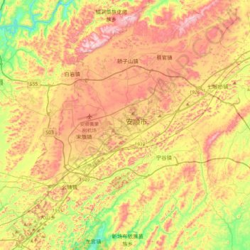
Name: Topografische Karte Anshun, Höhe, Relief.
Ort: Anshun, Xixiu, Anshun, Guizhou, 561000, China (26.09491 105.78378 26.41491 106.10378)
Durchschnittliche Höhe: 1.375 m
Minimale Höhe: 1.088 m
Maximale Höhe: 1.658 m
Anshun's administrative area spans latitude 25° 21'−26° 38' N and longitude 105° 13'−106° 34' E and contains sizeable areas of karst formation. It borders Guiyang, the provincial capital, and Qiannan Buyei and Miao Autonomous Prefecture to the east, Liupanshui to the west, Qianxinan Buyei and Miao Autonomous Prefecture to the south, and Bijie to the north. Within the prefecture, the elevation ranges from 1,102 to 1,694 metres (3,615 to 5,558 ft).