
Vielen Dank für die Unterstützung dieser Website ❤️
Spenden
Spenden
Topografische Karte Schizzanello
Klicken Sie auf die Karte, um die Höhe anzuzeigen.
Vielen Dank für die Unterstützung dieser Website ❤️
Spenden
Spenden
Über diese Karte
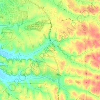
Name: Topografische Karte Schizzanello, Höhe, Relief.
Ort: Schizzanello, Roma, Lazio, 00134, Italia (41.73070 12.47947 41.77070 12.51947)
Durchschnittliche Höhe: 75 m
Minimale Höhe: 33 m
Maximale Höhe: 115 m
Vielen Dank für die Unterstützung dieser Website ❤️
Spenden
Spenden
Andere topografische Karten
Klicken Sie auf eine Karte, um ihre Topografie, ihre Höhe und ihr Relief anzuzeigen.
Riserva Naturale del Laurentino - Acqua Acetosa
Italia > Lazio > Roma > Roma > Mostacciano
Durchschnittliche Höhe: 34 m
Vielen Dank für die Unterstützung dieser Website ❤️
Spenden
Spenden
Vielen Dank für die Unterstützung dieser Website ❤️
Spenden
Spenden